Els Slots
Core Zone Findings
Some three months ago, I announced to the other members of the WH Map Data Working Group: “I found my new summer hobby!”. And I was right: I love learning a new skill and there is a meditative quality to nailing down a core zone in a specific way so it can be shown on our maps.
Here are my main findings after having added core zone maps to some 200 WHS. You can follow the current standings and future progress at the dedicated Forum Topic.
We cannot do all, but we can get far quickly
It seems a gigantic task, but progress has been good. On average, it takes me about 20 minutes to make one. And yes, of course, I am picking the low-hanging fruit first, but most natural WHS (often national parks displayed correctly on any map already) or the more recent cultural ones are easy to do. Cultural landscapes are a drama as they are a WH-specific “fiction”.
We can also import them from other sources: community members who did some mapping in the past, or “professional” resources such as Protected Planet (cooperating with IUCN for the natural WHS but not always correct), or the heritage organizations of the UK, Belgium, and the Netherlands. With the latter resources, they must have an explicit fair-use copyright for non-commercial use, and the file size (due to being very precise) can be an issue; therefore, these are not straightforward to use.
At this year’s WHC, the WH Bureau that administers the official documentation stated that 48% of the WHS do not have an adequate map yet. Taj Mahal has no map, the Ethiopian ones are an enigma, etc.. So in the best case, we could get the core zones covered for 52% = 649 WHS. I don’t know what their definition of “inadequate” is; I certainly have discarded much less than half of what I tried. As long as there are roads shown or plenty of other orientation points, I will manage.
Our core zone maps must be of functional use
Our core zone maps are not so detailed that you can define within a meter whether you have set foot in a core zone or not: this just requires too much work and would also lead to “heavy” maps that would perform poorly on a website.
The starting point is that they must be “functional”:
- They follow the Official UNESCO documentation: They include all components that comprise this WHS; so if a site has 3 locations, the core zone map shows these 3 locations. They are up-to-date with boundary modifications.
- They are usable for travel purposes: It is clear which major landmarks are inside and which ones are outside of the core zone.
The core zone mapping has uncovered previous mistakes
As always with taking on a project that handles all WHS, there’s a positive bycatch. While scrutinizing the PDFs of the official maps and the map information on the UNESCO website, you start to notice mistakes. The cause of errors could be made by the nominating State Party, or on our side by copy-paste mistakes, or due to third parties (Google Maps for example isn’t precise regarding locations in China and South Korea).
Some of the findings:
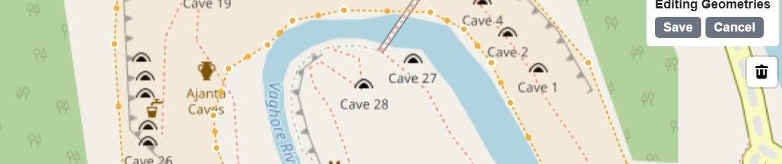
- Fairly often, the ‘dot’ we always had wasn’t exactly placed in the core zone: a good example is the Mausoleum of the Qin Emperor, which has a very specific archeological core zone surrounded by a much wider tourist area.
- Palmyra had a boundary modification a few years ago that we had not registered, as did Qal'at al-Bahrain.
- We found additional enclaves in Maloti-Drakensberg, Kakadu and Tongariro.
- Additionally, more sites with Incorrect UNESCO numbers of locations (Island of Mozambique, Maloti-Drakensberg, Guanacaste, Saryarka).
- And Reduced from Broader TWHS (Peruacu).
- Lake Turkana Parks do not include the lake itself.
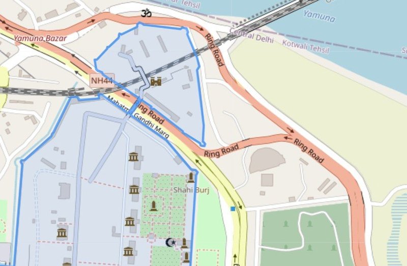
Also interesting to observe is that some WHS core zones are designed in such a way that they avoid a railway line (Tongariro) or a busy ring road (Red Fort Delhi, see image below). Corvey is not that small after all, and Bahla Fort is way more than a fort.
Finally, a big thanks to all who have contributed by sending in their own maps so far. Please keep on doing so: you can create a GeoJSON file, or do it in Google Maps and send us the downloaded KML-file.
Comments
No comments yet.