
Els Slots
F.A.Q. DIY Mapping Zones & POIs
The Site Maps on this website - the maps shown on the individual site pages for WHS, TWHS and FTWHS - are subject to a Community-Based Project to supply them with the outlines of the Core Zones and Points-of-Interest (POIs). This F.A.Q. aims to give instructions to those members who want to contribute by creating and submitting their own map-related data.
It covers the following subjects:
- Mapping Core Zones
- Adding Points-of-Interest
Mapping Core Zones
Introduction
A core zone map shows the outline of the Core Zone as defined in the UNESCO documentation.
Our core zone maps are not so detailed that you can define within a meter whether you have set foot in a core zone or not; this would require too much work and would also lead to “heavy” maps that would perform poorly on a website.
The starting point is that they must be “functional”:
- They follow the Official UNESCO documentation, which includes all components that comprise this WHS. Therefore, if a site has three locations, the core zone map shows these three locations. They are up-to-date with boundary modifications.
- They are usable for travel purposes: It is clear which major landmarks are inside and which ones are outside of the core zone.
How to create a core zone map for the website
There are different tools available to create such a map. To be able to show them on the website, they have to be stored in GeoJSON format. This means you have to create them directly in GeoJSON, or make them in a different tool (Google Maps, ArcGIS) and later convert them to GeoJSON (this can be done with KML and SHP files).
To create them directly in GeoJSON, you can use the free online tool geojson.io . It is easy to learn: just play around with it a bit or look for an online tutorial.
Things to note:
- The maps have to be created in the shape of a Polygon or MultiPolygon: only that way will it show as an enclosed area.
- "One WHS, one file": the file you create should cover one WHS only. If the WHS consists of multiple components, you combine them into that same file. Be sure here that these components will display in one layer: you can use the "merge vector layers" in a tool called QGis for that, or via the desktop version of Google Earth ("merge as one").
- Use the official map as given on the relevant site page on the UNESCO website as a reference. Look closely if you have the latest version; sometimes there have been boundary modifications after inscription.
- If there's no official map present, we will not create a core zone map either. We won't guess. This also means that TWHS or FTWHS cannot have core zone maps as at their stages, they won't have official maps.
How to submit a core zone map
If you have made a core zone map, send in the geojson file. We will then check it for validity before publishing it on the website. Once you have done a couple, we can also give you direct access as a geo editor so you can upload the files yourself.
How do I know which ones are still to do?
You can do it either way: select a WHS of your choice and look at the website to see whether it has a core zone map already. Or look at the Core Zone topic at the Forum where frequent updates are shared. There are still plenty left to do.
Adding Points-of-Interest
The core zone maps get even more value when Points-of-Interest are added to them. You can combine both in one file.
How to add a POI to a core zone
When using geojson.io, you can easily add one or more POIs to your core zone directly after you made it. Just use the option 'Draw Point' to indicate the exact spot you want to highlight.
Slight warning: don't add too many POIs to one file, as uploading will become a bit of an issue. 10 should be plenty. You can add additional ones later in a separate file.
To add a POI and show it in a meaningful manner, some metadata has to be prefilled. You can add those by clicking on the point, and use 'Add row' (one row per metadata item).
Syntax of the metadata
Metadata that can be pre-filled has to have the following syntax. The first term below always is the property name, the second (cursive just to clarify it here) is the property content:

- short_name This is the name of the POI. Max 30 characters inc. spaces.
- full_name This is the full name of the POI
- description This is a very short description of why this POI is interesting. Optional field.
- type A number that stands for the type of POI (viewpoint, museum, etc). The full list can be found here
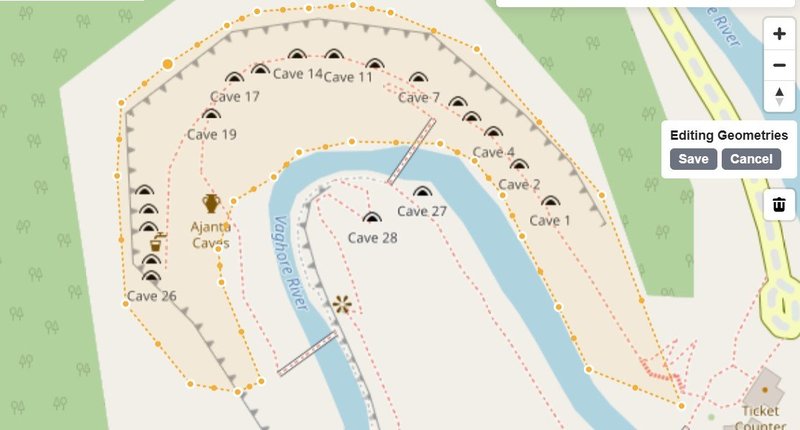
See the example to the right / below.
Comments
2 comments
This comment has been removed.