The Lofoten islands
The Lofoten islands is part of the Tentative list of Norway in order to qualify for inclusion in the World Heritage List.
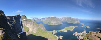
The Lofoten Islands lie north of the Polar Circle in the region of Nordland, which is topographically and biologically varied with islands with precipitous birdcliffs fringed by a narrow strandflat, sand dunes and bouldery beaches. Geologically the area belongs to the Lofoten Eruptive Province and consists chiefly of Precambrian rocks, the rocky shores are the principal type of shore in this region. Since pre-viking time the Lofoten islands have been and still are the centre for the Norwegian cod-fisheries. The area was settled very early and contains many unique cultural monuments.
Map of The Lofoten islands
Load mapThe coordinates shown for all tentative sites were produced as a community effort. They are not official and may change on inscription.
Community Reviews
Nan

Thanks to plentiful cod in the sea around the Lofoten, the Lofoten saw a huge influx of fishers each winter. From January to March each year is cod season and fishers would come past the polar circle for catching them. They would then be hung up to dry and sold South.
On the Lofoten, small fishing villages developed where fishers could land and sleep (rorbuer). Nowadays, you can rent their huts for staying yourself. These fishing villages are tucked against the mountains that form the backbone of the Lofoten. It's this combination of fishing villages and nature that marks the magic of the Lofoten.
OUV
The Lofoten would easily be Norway's second best WHS (after the fjords). OUV would be gorgeous nature combined with the fishing activities. The villages and huts are just iconic. And the views... I would probably rate it 4-4.5 stars. Similar sites I have seen so far would be Fjordland in New Zealand and Los Glaciares in Argentina, both of which I would rate higher. Fjordland is more unspoiled nature and covers a wider range of ecosystems. Los Glaciares has Perito Moreno, Fitz Roy, ...
When it comes to the question what precisely will be inscribed, the current nomination site doesn't hold much information. I would guess the bird areas on the outer islands, the National Park and the traditional fishing villages should be part of the core zone. With Ryten and Nusfjord I covered two of three of these.
Getting There
Somewhat surprising given their popularity with tourists, the Lofoten do not boast an international airport. Leknes and Svolvaer are local airports and the main flights are to Tromsø and Bodø. So even coming from Oslo you will have to change. And note: The flights are really expensive.
The standard way of reaching the Lofoten is by ferry from Bodø. Flights to Bodø are reasonably priced and unless you have a car the ferry trip to Moskenes is straightforward with great views of the coast and the islands. There is also an express boat from Bodø to Svolvaer. Connections to the smaller islands run from Moskenes.
For those keen on taking a bus, there is a bus connection from Narvik that covers most of the main towns on the Lofoten and ends in A.
Personally, I came from Bodø where I stayed overnight by ferry. And I flew out from Leknes to Tromsø from where I traveled on to Alta.
Getting Around
The Lofoten have one principal road that connects the principal towns (E10). Along the road, there are buses that run roughly every 1.5h. It's best to check the schedule in advance and plan your times accordingly. The bus stops are marked, but always safer to signal the driver to stop. Tickets are bought via app. The bus arrival / departure times in Moskenes are aligned with the ferry times.
Tiny problem with the bus stops: Several places are off the main road and require some walking. Nusfjord is a 6km walk. The trailhead for Ryten 3km. But otherwise it's fine. To find the bus connection you have to search for kryss (junction), e.g. Fredvang kryss.
Tiny problem, this time with walking: Most of the time you walk on the road. The traffic especially on the E10 can be quite heavy so it wasn't always pleasant.
Where to Stay
I stayed in Hamnoy and found that the towns between Reine and Hamnoy were the nicest. You get great sunsets, a picturesque view, there is a supermarket and a baker, and by bus you can travel to most parts of the island as a day trip. So I would recommend that.
Itinerary
I split my visit into three parts.
Day 1 - Arrival and hike up Reinebringen. Thanks to newly installed steps it's not a technically challenging hike anymore. Still, more than 1500 steps are strenuous. The views you get from the top are stunning.
Day 2 - Hike to Ryten and Kvalvika Beach. Took the bus to Fredvang Junction and then walked. Views from the bridge were (again) stunning. Views on the trail as well. The descent from Ryten to Kvalvika Beach was rather challenging as the trail was in poor shape. But who could say no to such a beautiful beach.
Day 3 - Visited A, then Nusfjord. A was rather dull and the famous bakery (not yet) open. But you did get a view of the Southern islands. Nusfjord is the oldest fishing village of the island and nowadays a preserved museum. In the evening, I departed from Leknes.
All days were great and I would recommend the same itinerary. If you stay longer, my recommendation would be to at least visit one of the outer islands. There is also a trail from A along the west coast. With even more time, you may want to look into the northern Loften.
Argo

We spent several days in Lofoten islands in summer 2016, and this was one of the highlights of our Norway trip (a country which is one of the best – if not the best – in Europe for landscapes and nature lovers). We were lucky enough to enjoy sunny weather during our stay, giving blue and turquoise color to the sea along white sandy beaches (from the pictures, this looked like tropical country, but actual air temperature never exceeded 15°C during the day!). From Unesco website, it can be understood that this TWHS is proposed as a mixed site and encompasses the south-westernmost islands of the archipelago.
We arrived by ferry from Bodo to Moskenes (it takes around 3 hours), and this was a stunning introduction to the place : sharp mountains range (some 250 km long) “grows up” over the horizon line as the ferry goes, and this combination of sea and mountain in one single landscape is one of the most beautiful in Norway. This experience was different and, in some way, complementary to our visit to the West Fjords a few days before. Lofoten islands are nothing but an old mountain range (some of its rocks are some billion years old), in the middle of the sea, eroded by successive glacial eras and resulting in cliffs, sharp peaks, bays, fjords, with few and narrow places left for human settlements. This geological process for sure would be promoted as one of the reasons for inscription. They are many places for hiking, and trails of all levels of difficulties.
The area is also rich in sea birds colonies; but we could not really appreciate this aspect (we should have extended our stay to some of the smallest and most remote of the islands). Though we visited the “Lofoten aquarium” (the kids really enjoyed it) and took part to a “safari whales” later (from Andenes, northernmost point of nearby Vesteralen islands), these places seem to be out of this TWHS boundaries.
Cultural aspect of this nomination is linked to fishing activities. Lofoten islands are famous for cods, which are caught during their migration (January to April) along the islands. Everyone knows the iconic red fisher huts (called “rorbuer”) on poles overlooking the sea. We visited the village called A (the shortest name of all the places we ever visited!), where most of the buildings are still the original ones and can be visited: housing, shelters for boats maintenance, black-smith workshop, fish processing area (we could even taste the famous cod liver oil!). In summer, the most valuable part of the cods has already been processed and exported, but cods’ heads, which are lower value, are still drying on tall open-air wood structures in this period of the year: this gives to the visit an “unforgettable smell”. Humans have been living and fishing in Lofoten islands for centuries (there are remains from Viking era, and before), which is remarkable considering the remote location of the islands (and not even mentioning that they are 200 km north of the arctic circle, so without any sunlight for approximately two months in winter). We stayed some nights in a rorbuer in another fishing village, now mainly dedicated to host tourists. This was obviously a great family experience. Tourism is now the main activity during summer months, but still this activity is well managed, including renovation of old buildings, preservation of the existing places without any damageable alteration: the global feeling is that these places are still quite “authentic”.
After this stay in Lofoten islands, we left for Andenes (Vesteralen). From there the next day, we took the early morning ferry to Senja island, a place less visited but with very nice landscapes as well, and, using another ferry, we reached Tromso in the evening. This made a fantastic itinerary from Bodo to Tromso, from island to island only, and an excellent alternative to the main road on the continent.
We have no doubt Lofoten islands deserve their place on the WH list, would Norway decide one day to put forward this nomination.
Community Likes
Site Info
- Full Name
- The Lofoten islands
- Country
- Norway
- Added
- 2002
- Type
- Mixed
- Categories
- Natural landscape - Marine and Coastal
- Link
- By ID
Site History
2002 Added to Tentative List
Site Links
Visitors
59 Community Members have visited.