Quttinirpaaq
Quttinirpaaq is part of the Tentative list of Canada in order to qualify for inclusion in the World Heritage List.
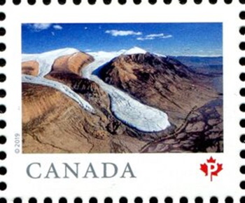
Quttinirpaaq National Park of Canada (37 775 km2) covers the northern portion of Ellesmere Island. Unique physical features are the ancient deposits of 80 m-thick freshwater ice shelves that extend several kilometres out over the Arctic Ocean. All pre-contact cultural groups known to have occupied High Arctic Canada, including Independence I (4500-3000 years ago) and Independence II (ca. 3000-2500 years ago), Late Dorset (ca. 1300-800 years ago) and Thule (ca. 900-300 years ago), are represented by archaeological sites in the park, and thus has the highest concentrations of pre-contact sites surveyed in the High Arctic, including sites associated with the earliest documented human inhabitants of this remote region.
Map of Quttinirpaaq
Load mapThe coordinates shown for all tentative sites were produced as a community effort. They are not official and may change on inscription.
Community Reviews
No reviews yet. Be the first!
Site Info
- Full Name
- Quttinirpaaq
- Country
- Canada
- Added
- 2004
- Type
- Mixed
- Categories
- Archaeological site - Pre-Columbian Natural landscape - Glaciation
- Link
- By ID