Makgadikgadi Pans Landscape
Makgadikgadi Pans Landscape is part of the Tentative list of Botswana in order to qualify for inclusion in the World Heritage List.
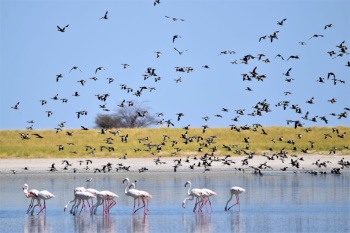
The flat, white Makgadikgadi Salt Pans are among the largest salt pans in the world. On the fringes grow baobabs. The area covers Nata Bird Sanctuary too which is one of the world’s largest breeding sites of Lesser and Greater flamingo. The landscape also has produced evidence of early human habitation from the Stone Age onwards.
Map of Makgadikgadi Pans Landscape
Load mapThe coordinates shown for all tentative sites were produced as a community effort. They are not official and may change on inscription.
Community Reviews
Randi Thomsen

The proposed Makgadikgadi Pans Landscape consist of three different locations the Makgadikgadi National Parks, Nxai Pan National Park and Nata Bird Sanctuary.
We managed to visit all three of them on our Namibia-Botswana roadtrip in April 2019.
From Kasane to Maun we did a stop-over close to Gweta. We stayed at Planet Baobab. As the name indicates, they had 17 great baobab trees on the hotel premises. The lodges were in traditional style, a great place to stay and convenient for a visit Makgadikgadi Pans Landscape. Enroute we made a visit to Nata Bird Sanctuary, truly a great place. It is one of the largest breeding sites of Lesser and Greater flamingo in the world and there were thousands of them on the shores of the pans along with other birds like pelicans, eagle, storks, and several different waders. We almost had the whole sanctuary to ourselves, really a beautiful place. A 4x4 car is recommended.
We arrived at the hotel early afternoon and decided to pay a visit to the eastern end of the Makgadikgadi National Park. A 4x4 is a must here. We spotted a great number of zebras along the way. The park is a feeding place to one of the most spectacular zebra-wildebeest migration on earth as they move from Boteti River to Chobe during dry season. Thinking back we recalled seeing none in Chobe. We were heading to the rim of the pans, but had to turn in order to exit the park before dark. Driving is very slow due to narrow sandy and deep tracks and we barely made it out in time.
The next day we started out with a visit to Nxai Pan. From the main road to the park entrance is 35 km on very bad tracks. Nxai pan used to be salt pans, but it is now overgrown providing a great feeding area for animals. We spotted plenty of animals in almost solitude. The park is definitely not on the main tourist track. There are also remnants of prehistoric settlements in the park.
We still had some time left that day and decided to move on to Boteti river in Makgadikgadi National Parks (west side). We troubled to find the entrance as it looked like a closed fence, but when we looked at the small note at the fencepost, it was to free to enter - just open and close the gate.
There are large distances in this park, 30 km to Boteti from the gate. Time consuming driving on narrow sandy tracks with sudden animals crossing. But it was all worth it. Looking out on Boteti River Basin was like garden of Eden, so beautiful with unspoiled nature and plenty of all kinds of animals at the riverbanks.
We enjoyed our visit to Makgadikgadi Pans Landscape. Well worth spending an extra day. A joint inscription with Etosha Nationalpark, Namibia will be welcomed.
### Randi & Svein Elias
Site Info
- Full Name
- Makgadikgadi Pans Landscape
- Country
- Botswana
- Added
- 2010
- Type
- Mixed
- Categories
- Cultural Landscape - Relict Natural landscape - Rivers, Wetlands and Lakes
- Link
- By ID
Site History
2010 Revision
Successor to former TWHS Makgadikgadi Cultural Landscape (1999)
2010 Added to Tentative List
Site Links
Visitors
9 Community Members have visited.