Georgetown's Plantation Structure and Historic Buildings
Georgetown's Plantation Structure and Historic Buildings is part of the Tentative list of Guyana in order to qualify for inclusion in the World Heritage List.
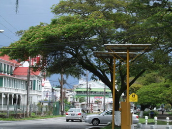
Georgetown's Plantation Structure and Historic Buildings comprises the townscape and 19th century colonial architecture of Historic Georgetown (then called Stabroek). Georgetown is laid out in a north–south, east–west grid, interlaced with canals protected by sluices, built by the Dutch and later the British that provide drainage to a city that lies below high-tide level. The former plantation grounds can still be seen in the urban lay-out and the positioning of the canals, of which the Cummings Canal and the canal on Croal Street remain.
Map of Georgetown's Plantation Structure and Historic Buildings
Load mapThe coordinates shown for all tentative sites were produced as a community effort. They are not official and may change on inscription.
Community Reviews
No reviews yet. Be the first!
Site Info
- Full Name
- Georgetown's Plantation Structure and Historic Buildings
- Country
- Guyana
- Added
- 2005
- Type
- Cultural
- Categories
- Urban landscape - Colonial
- Link
- By ID
Site History
2005 Added to Tentative List
Site Links
Visitors
16 Community Members have visited.