Aqueduct of Padre Tembleque
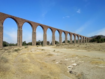
The 'Aqueduct of Padre Tembleque Hydraulic System' encompasses a 16th-century canal system that is unique in the Americas.
The system was initiated by Franciscan friars. It carried water from the Tecajete volcano near Zempoala to the city of Otumba, over a distance of 48 km. Spanish engineers and local craftsmen worked on the construction, using European and indigenous techniques.
Community Perspective: To see the aqueduct above ground you’ll need a car. A good viewpoint lies just outside the town of Santiago Tepeyahualco. It can be combined with a trip to Teotihuacan but beware of bad roads. An alternative visit can be made to the towns of Otumba and Zempoala, the endpoints of the system.
Arab-Norman Palermo

Arab-Norman Palermo and the Cathedral Churches of Cefalú and Monreale show an exceptional exchange between Western, Islamic, and Byzantine cultures.
The monuments date from the era of the Norman kingdom of Sicily (1130-1194). Muslim, Byzantine, Latin, Jewish, Lombard, and French elements were combined into a new architectural and artistic style. It is characterized by rich decorations such as mosaics, paintings and fittings.
Community Perspective: It’s hard to name highlights, as the component sites are all good and every reviewer seems to have his or her own favourite. Clyde and Matejicek managed to visit all 9 locations; it will take you 2-3 days.
Baekje Historic Areas
The Baekje Historic Areas cover the archeological sites of three capital cities from the late Baekje Kingdom that represent its unique culture.
In the 5th-7th centuries, the Baekje implemented Chinese principles of city planning, construction technology, arts and religion into the subsequent capitals of their kingdom: Gongju, Buyeo and Sabi. They further refined them and spread them to Japan and the rest of East Asia.
Community Perspective: Els and Frederik have visited the remains of Gongju, while Clyde focused on Buyeo. The Iksan cluster however is the most remarkable one according to Philipp who visited all clusters. Kyle has shared the history of the Tomb of King Muyeong and Mireuksa Temple. GabLabCebu admired the stonework of the latter.
Baptism Site "Bethany Beyond the Jordan"
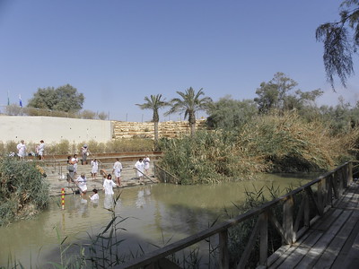
The Baptism Site "Bethany Beyond the Jordan" (Al-Maghtas) is a Christian pilgrimage site commemorating the location where Jesus of Nazareth was baptised by John the Baptist.
It also represents the Christian important tradition of Baptism - archaeological evidence of the practice of baptism here dates back to the 4th century and baptism rituals are still held at this site. The site, located on the eastern banks of the Jordan River, has been a place of pilgrimage for millennia
Community Perspective: The main focus of the obligatory tours is the Jordan River, where you can watch others being baptised (also on the Israeli side) or immerse yourself, and the actual spot where Jesus was baptized which is quite far from today's river. Stanislaw also covered the associated site of Jabal (Tell) Mar Elias.
Blue and John Crow Mountains
The Blue and John Crow Mountains are a remote mountainous region known for its biodiversity and relevance to the history of Jamaican Maroons.
The region provided refuge to escaped indigenous slaves, the traces of which can be seen at Maroon archaeological sites such as hiding places and a network of trails. They lived in and around the settlement of Nanny Town. The area is limited to the Preservation Zone of the Blue Mountains and John Crow Mountains NP. These mountain ranges are covered with dense tropical, montane rainforest. A wide variety of endangered and/or endemic plant, frog and bird species is found here.
Community Perspective: the Blue Mountains and its coffee history are well on the Jamaican tourist trail, but visiting the rather limited core zone of old forest is another cup of tea. Els has described the options for a rewarding visit.
Burgundy
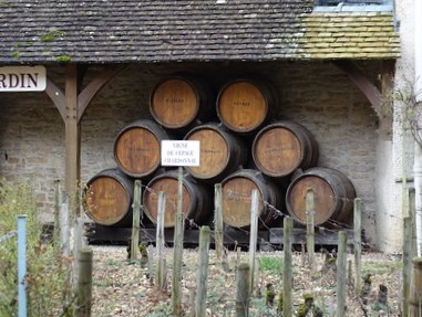
The Climats, terroirs of Burgundy comprise a vineyard historic landscape organized around delimited parcels.
The 1,247 vineyards are distinct from one another due to their specific natural conditions such as soil and microclimate, resulting in many vintages. The commercial town of Beaune and the political and regulatory center of Dijon complemented the system. The Ducal Palace of Dijon, the Hospices of Beaune and the Clos de Vougeot Chateau represent the tangible trace of these viticultural actors.
Community Perspective: For those tired of vineyards, this site also includes two historic towns. The historic Duchy of Burgundy left a splendid highlight in the Hospices of Beaune (it could/should have been a WHS in its own right). In Dijon, the Ducal Palace and the Place de La Liberation stand out.
Champagne
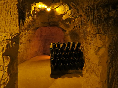
'Champagne Hillsides, Houses and Cellars' is a cultural landscape shaped by the production of sparkling wines since the 17th century.
This is a living and working environment, with trade towns, prestigious commerce houses and the underground heritage of the wine cellars in former chalk quarries. The agro-industrial part includes the vineyards and the processing sites.
Community Perspective: This site focuses more on the industrial and commercial process of champagne production than on vineyards, so it’s appropriate to visit one of the Champagne Houses, that’s also the way to get into one of the chalk cellars. All major brands (Pommery’s, Taittinger) offer popular tours.
Christiansfeld
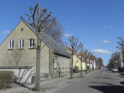
Christiansfeld, a Moravian Church Settlement, is a townscape that resulted from a planned idealized Protestant colony.
The town was founded in 1773 by the Moravian Church, following a strict plan with homogenous and unornamented buildings. It reflects the Church’s principles such as including buildings for the common welfare. From the German village of Herrnhut, the first Moravian missions were directed to northern Europe and Christiansfeld is the best-preserved example of such settlements.
Community Perspective: there is a heritage trail with 27 locations that you can follow around town, but it still covers two streets only. The church and the cemetery are worth a visit, as is the Christinero which lies a bit further away in the buffer zone. Caspar stayed overnight and Jay compares Christiansfeld with a visit to Moravian Bethlehem.
Diyarbakir Fortress and Hevsel Gardens
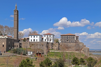
The Diyarbakir Fortress and Hevsel Gardens Cultural Landscape comprises a fortified settlement along the Tigris River, which played an important role in many civilizations.
Its long history includes Roman, Byzantine, Umayyad, Artuqid, Seljuk and Ottoman periods. The Diyarbakır City Walls stretch for 5,800 metres with many towers, gates, buttresses and historic inscriptions.
Community Perspective: The site isn’t very well preserved, read Clyde and Stanislaw’s reviews for what ‘issues’ you may encounter. To appreciate the walls, you can do the extra-muros circuit where you’ll encounter some of the inscriptions (walking on the walls itself is hardly possible).
Ephesus
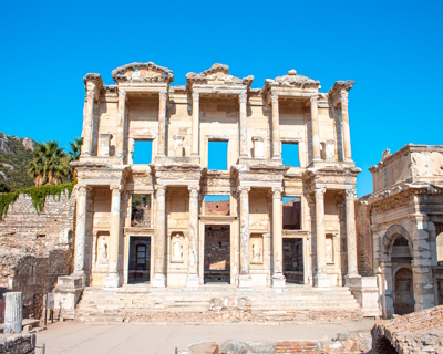
Ephesus contains successive settlements from the Neolithic, Hellenistic, Roman, Byzantine, Selçuk and Ottoman periods.
The site started out as a sanctuary for Artemis, here worshipped as the mother goddess. Its main surviving monuments date from the Hellenistic and Roman Imperial periods, with religious and public buildings decorated with wall paintings, mosaics and marble panelling. The area also includes Cukurici Mound (a Neolithic settlement) and the Christian pilgrimage sites of the Church of Mary and the Basilica of St. John.
Community Perspective: Focus on the main site, with the restored façade of the Library of Celsus, the large theater and the wall paintings and mosaics of Terrace House 2. The Christian sites are “interesting but far from breathtaking”.
Forth Bridge
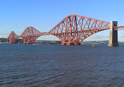
The Forth Bridge is an early steel cantilever railway bridge that is a milestone in the evolution of bridge design.
Built in the age of the expansion of the railways, it still connects Edinburgh with Fife over the estuary 'Firth of Forth'. Remarkable is its size, at 2,529 m it remains one of the longest cantilever bridges, as well as its industrial looks. To prevent the steel from rusting, the structure is covered with a red protective coating.
Community Perspective: The bridge isn’t visible very well while you’re on it in a train; better views to admire its massive scale can be had from Blackness Castle, near the water’s edge in South Queensferry, from the Road Bridge, from the water via a boat trip, or from the air when landing at Edinburgh Airport.
Fray Bentos

The Fray Bentos Cultural-Industrial Landscape is a port area shaped for the industrial production of canned and frozen meat.
In 1865, a meat processing and packing plant aimed at the European market was started here on the Uruguay River. The whole process starting from cattle pastures til the shipping of the goods was done on-site. It attracted immigrant workers from over 55 countries. The factory closed down in 1979. Remains include the enormous cold storage building, a tall brick boiler chimney, workers’ housing, holding pens and the slaughter yard.
Community Perspective: it’s a fascinating and extensive site, with a modern visitor center and a museum. Several tours are on offer to explore restricted parts such as the manager’s residence or the factory plant.
Great Burkhan Khaldun Mountain
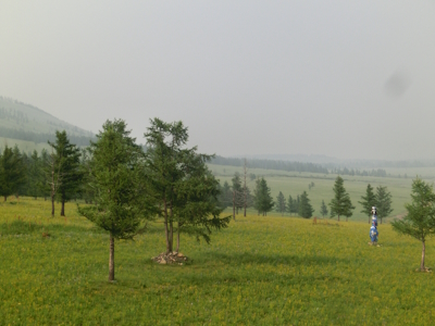
The Great Burkhan Khaldun Mountain and its surrounding sacred landscape represent the formalised mountain worship by Chinggis Khan which helped to unify the Mongolian Empire.
The permanently snow-capped Burkhan Khaldun is one of four sacred mountains of that period when official status was given to the long-standing shamanic traditions of mountain worship by the nomadic peoples. It also is the reputed burial site of Chinggis Khan. The landscape further holds a pilgrimage path and three major stone ovoo-s. The mountain and its history is described in the epic 'The Secret History of the Mongols'.
Community Perspective: Michael is the first and only reviewer so far: he was able to reach the site in wintery circumstances and enjoyed the remote, wide-open, mountain scenery. He has described his visit in detail, with both practical information (there is an entrance fee!) and an interpretation of the site’s meaning.
Maymand
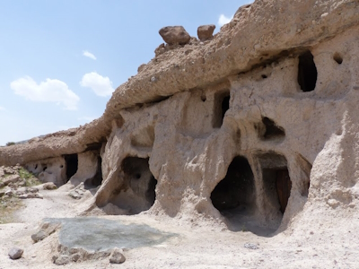
The Cultural Landscape of Maymand covers a dry desert valley in Central Iran, which is home to semi-nomadic people.
The mainly self-sufficient community practices a three-phase transhumance system, where they move between three settlements. In winter, they live in troglodytic houses carved out of soft stone rocks. The area contains houses, animal shelters, water collection points, agro-pastoral systems and rock art.
Community Perspective: This is well on the beaten path of the foreign tour group circuit, so be prepared to “be ‘invited’ to buy artefacts or the local honey!”. Alexander had a peculiar experience while staying overnight.
Necropolis of Bet She'arim

The Necropolis of Bet She'arim - A Landmark of Jewish Renewal covers burial catacombs from an important period in Jewish history.
It comprises the archeological site of a Jewish town and 33 ancient rock-cut Jewish tombs. Rabbi Judah the Patriarch lived here, and it became the preferred burial place for Jews after they were barred from the Mount of Olives during the Roman occupation. The catacombs contain inscriptions written in Greek, Hebrew, Aramaic and Palmyrean and images showing the exchange with the Greco-Roman world.
Community Perspective: Obviously the site is popular mostly with Jewish visitors. Not all caves are accessible and to a WH chaser the two main caves nearest to the visitor center offer 90% of the overall value.
Par force hunting landscape
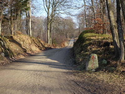
The par force hunting landscape in North Zealand is an intentionally designed landscape used for hunting by the Danish kings in the 17th and 18th centuries.
‘Par force’ stands for ‘by force (of dogs)’, the noblest form of hunting where a specific animal was run down and exhausted by mounted hunters and dogs before the kill was made. This technique was developed in France and adopted widely across Europe by the royalty and nobility to display their power. The landscape consists of man-made forests and ride systems in a rigid orthogonal grid pattern.
Community Perspective: the easiest to visit component is Jægersborg Dyrehave just outside of Copenhagen, but read Ian’s review on why you shouldn’t. Clyde visited Gribskov Forest (“can only be really appreciated using drone photography”) and Store Dyrehave (like a treasure hunt), as did Els.
Rjukan / Notodden
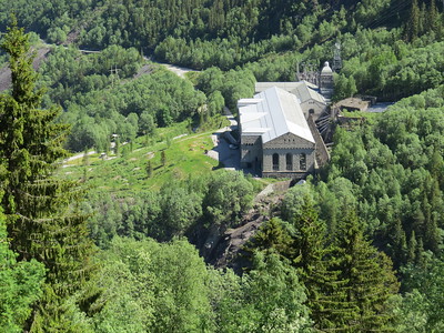
The Rjukan / Notodden Industrial Heritage Site covers a former production complex that used revolutionary hydroelectric power plants in the Måna River and its waterfalls.
The complex was established by the private Norsk-Hydro company in the early 20th century to produce hydroelectricity and manufacture artificial fertilizer. It used the natural topography to generate the large amounts of power needed. The site includes both the technological components such as dams, tunnels and power plants, and the company towns of Rjukan and Notodden.
Community Perspective: located in a beautiful Norwegian landscape, but the site itself can be a bit hard to grasp and covers a stretch of some 80km. Juha recommends walking along the river Måna all the way from Rjukan to Vemork power station and Rjukanfossen waterfall.
Rock Art in the Hail Region
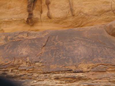
Rock Art in the Hail Region of Saudi Arabia consists of two sites with petroglyphs and inscriptions.
The rock carvings date back to almost 10,000 years ago, when there was a valley here with flowing water which has now disappeared. Humans and animals are depicted. The two components are Jabal Umm Sinman at Jubbah and Jabal al-Manjor and Jabal Raat at Shuwaymis.
Community Perspective: So far only the Jubbah component, the easiest to access, has been reviewed. The engravings have good details. You need a guide to point out the harder-to-find ones.
San Antonio Missions
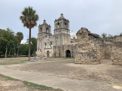
The San Antonio Missions were created by the Franciscan Order in the 18th century to evangelize the indigenous Coahuiltecan population and create settlements loyal to the Spanish.
The five missions that were meant to be self-sustaining communities are located along the San Antonio River in Texas. They include farmlands, residences, churches, workshops, wells and water distribution systems. The decoration of the churches combined Catholic symbols with indigenous natural design. Included are: Mission Valero, Mission Concepción, Mission San José, Mission San Juan, Mission Espada and Rancho de las Cabra.
Community Perspective: Mission Valero is by far the most touristy/tacky of the group for its association with the historic Battle of Alamo, but WH travellers are better off at the other locations. Frederik describes a visit to Mission San José, reputably the largest and most beautiful of all missions, while Jay enjoyed Mission Espada. And Kyle recommends the bike trail that connects all of the missions.
Singapore Botanic Gardens
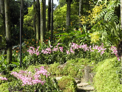
The Singapore Botanic Gardens comprise a garden landscape that started as a British tropical colonial botanic garden.
The gardens were created in 1859, and have been a centre for plant research since. They played a pivotal role in the region's rubber trade boom in the early twentieth century, when they headed research into the plant's cultivation. By perfecting the technique of rubber extraction and promoting its economic value to planters in the region, rubber output expanded rapidly.
Community Perspective: Easily accessible by metro from the city center and the airport. Feels more like a park than a heritage botanic garden, and the rubber connection isn’t obvious. Most consider that its highlight is the National Orchid Garden, which – in contrast to the rest of the Botanic Gardens – requires an entrance fee.
Sites of Japan's Meiji Industrial Revolution
The 'Sites of Japan's Meiji Industrial Revolution: Iron and Steel, Shipbuilding and Coal Mining' are industrial heritage sites that reflect Japan’s rapid industrialisation between 1853 and 1912.
The success in the field of heavy industry was based on the adaptation of Western technology and further local innovation to meet specific Japanese needs. The 23 locations, mostly in southwest Japan, include shipyards, mines, and furnaces, but also public and residential buildings in a mix of Japanese and European architectural styles.
Community Perspective: Glover House in Nagasaki is the easiest location to access, while Gunkanjima (a.k.a. Battleship Island) may be the strongest. Locations covered include Town of Hagi (Els), Shuseikan (Frederik), Gunkanjima (Frederik, Anthony, Michael, Daniel), and Nirayama Reverbatory Furnace (Alexander, Hubert).
Speicherstadt and Kontorhaus District
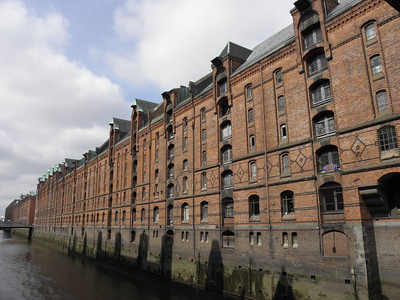
The Speicherstadt and Kontorhaus District with Chilehaus represent the warehouse-office district of the port city of Hamburg.
The warehouses and offices, together with their connecting network of streets, canals and bridges, date from the late 19th and early 20th centuries. The iconic Chilehaus, a ten-story office building, is an exceptional example of the 1920s Modernist architecture (in the Brick Expressionism style) that defines this district.
Community Perspective: Nan has provided a local perspective, while Assif shares some insights on its architectural history. The Chilehaus is considered the area’s highlight.
Susa
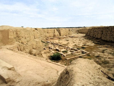
Susa comprises the remains of an ancient city that is known for its contribution to the development of the early state and urbanization.
One of the oldest-known settlements of the region, dating from as early as 4395 BCE, it became the capital of the Elamite and Achaemenid empires. During the Elamite period, it already showed the beginnings of urban development. 27 layers of superimposed urban settlements have been uncovered. During the Achaemenid period, a new type of ceremonial architecture was developed here at the Royal Palace of Darius and Apadana.
Community Perspective: “Susa is one of those Archaeological sites whose fame and significance outweigh what is actually ‘on show’”. Still, it is worth visiting: Solivagant has detailed a visit of about 2 hours.
Tusi Sites
The Tusi Sites are three examples of the Tusi system in which the inheritance of official positions was granted to tribal leaders in ethnic minority regions.
The practice was used in China’s feudal period between the 13th and 20th centuries. Laosicheng Site, Hailongtun Site and Tang Ya Tusi Site are the archaeological remains of former tribal domains located in mountainous regions in southwest China. They are also testimony to the traditional cultures and cultural practices of the Tujia, Gelao and Miao Ethnic Peoples.
Community Perspective: Frederik made an almost accidental visit to "Tujia Old Fortress” in Laosicheng in 2011, while Stanislaw visited that same site in 2019 and explained the logistics for individual travellers. Zos managed to visit all three components.
Extended Sites in 2015
Cape Floral Region
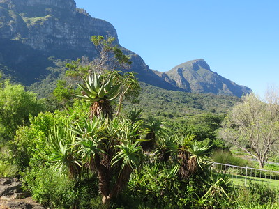
The Cape Floral Region Protected Areas consists of 13 clusters covered with fynbos and known for their rich plant life.
They are located in the Mediterranean climate region of South Africa Western Cape Province and the Eastern Cape Province. With the Cape Floral Region being of the six Floral Kingdoms of the world, the outstanding diversity, density and endemism of the flora are among the highest worldwide.
Community Perspective: The site comprises 13 locations, of which Table Mountain and the Kirstenbosch Gardens are the most accessible as they lie in Cape Town. Bernard has given an overview of some other clusters that can be done self-driving. August/September is the best time to see the flowers.
Adrian Lakomy Slovakia - 01-May-05

Visiting Cape Town a collector can visit 2 sites. First is Robben island and second is Cape Floral Region.
This site consists of six (?) parts which are geographicaly in whole region of Western Cape.
So I visited only the "Kirstenbosch Botanical Garden" and Cape Point National park. The whole region is a housing of Fynbos ("fine bush") which is rare only for this part of world. The natural location is very nice and I enjoyed my stay there, especialy on Cape Point even it is very windy. Just be prepared that you will need a whole day for such a trip.
Read OnPhong Nha - Ke Bang
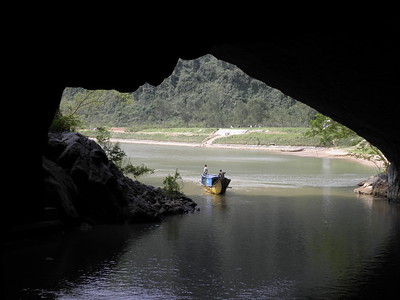
Phong Nha - Ke Bang National Park contains a complex karst system that is one of the oldest and largest in Asia.
The limestone landscape includes underground rivers and very large caves, such as the Son Doong Cave, first explored in 2009, which is the world’s largest known cave passage in terms of diameter and continuity. The caves hold many geomorphic features such as dry caves and sub-aerial stromatolites. The park is covered by (mostly primary) tropical forest and has a high floral and mammal biodiversity.
Community Perspective: This can be done as a day trip from Hué, but allow yourself plenty of time to enjoy the site (at least 3h). You can visit the Phong Nha cave in a small boat, which lets you ashore a few times as described by Els. The Paradise Cave supposedly is more spectacular – read Zoë’s review for that one. And Martina made it to the Dark Cave as well.
anthony Sun USA - 21-Dec-08
Phong Nha is part of unique set of cave systems in the world in that it has a subterranean river flowing through the cave and out and the river is navigable by boat. This allows the visitor a unique experience to sit in a boat and either paddle or cruise through the cave while admiring the experience.
My family and I experienced Phong Nha in 2005. The starting point is the town of Dong Hoi which is access able from Hanoi or Ho Chi Minh. A short drive brings you to Phong Nha which is a pleasant place to walk among the mountains. The cave is located on the river and boats can be rented to paddle you in. The cave is about 5 miles deep but the boat will take you less than a mile and then you get to walk in dry caves looking at the rock formations.
Read OnRoute of Santiago de Compostela
Routes of Santiago de Compostela: Camino Francés and Routes of Northern Spain comprise four historic Christian pilgrimage routes originating in the Middle Ages.
The routes drew pilgrims from the Iberian Peninsula and the rest of Europe. They start from the French-Spanish border and end at the Cathedral of Santiago de Compostela, where the remains of the apostle Saint James the Great are said to be buried. Along the route, there are over 1800 associated historic buildings, including cathedrals, churches, monasteries, hospitals, inns and public works.
Community Perspective: This is best experienced on foot of course, and Clyde has completed the full Camino. Others like Jay (six days), Ian (120km) and Frederik (7km) did parts of it.
Solivagant UK - 22-Jan-06

Why on Earth is this inscribed as a separate site from Santiago de Compostela itself? So little of visual consequence was the UNESCO Web site apparently able to find along the route that it even uses a picture of the Cathedral at Santiago to introduce it! And then, of course, France has inscribed its part of the pilgrimage route separately (see my review) – making a total of 3 “Compostela” inscriptions in all.
I would not argue against inscribing the pilgrimage route. So significant was the journey and so long did it take that it is studded by buildings created to support the pilgrimage but by splitting the objective from the journey (and by splitting even that into 2) UNESCO and Spain/France have, in my view, belittled the totality. And for what – political reasons no doubt? Yet the entire route in both France and Spain has been designated as the first “European Cultural Itinerary” so cooperation was achieved in that case – why not in UNESCO? Spain’s policy regarding WHS nominations has always been to “share out” its sites across its Autonomous Regions and the Compostela Route gives 5 of them a “share”
Read On