Albi
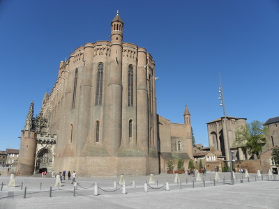
The Episcopal City of Albi comprises an urban landscape with outstanding medieval architecture.
The city was built around the original Cathedral and episcopal group of buildings after the Albigensian Crusade. Fired brick and tiles are the main features of most of the edifices. The Sainte Cécile Cathedral, built as a statement of the Christian faith after the upheavals of the 13th-century Cathar heresy, is considered a masterpiece of the Gothic style of Southern France.
Community Perspective: More interesting than it seems at first sight. The red brick Cathedral is huge and peculiar, with amazing interior decoration. Together with the former Archbishop's palace next door, which houses a museum of the favorite local son Henri Toulouse-Lautrec, it forms a harmonious ensemble.
Amsterdam Canal Ring
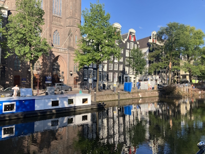
The Seventeenth-century canal ring area of Amsterdam inside the Singelgracht comprises an urban landscape that is a masterpiece of hydraulic engineering, town planning, and bourgeois architecture.
The port city is centered around a half-moon-shaped network of canals that were dug to extend the medieval city center. The city was expanded at the most in the 17th century when Amsterdam had become a wealthy maritime trade metropolis. The nucleus of the nomination lies along the Singel, Keizersgracht, Herengracht, and Prinsengracht. The residences here are known for their variety of gabled facades.
Community Perspective: The best time for a visit to Amsterdam is early Sunday morning and then just soak up the unique atmosphere of the city by walking along its canals. The best views of its architecture are to be had from a canal cruise boat. Hubert has recommended some canal houses that are open to visitors.
Australian Convict Sites
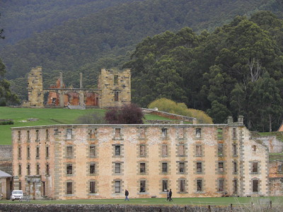
The Australian Convict Sites comprise the remains of settlements to which British convicts were migrated by force.
The transportation and associated forced labour was a legal form of punishment in the 18th and 19th centuries. It also led to an influx of European colonists to the detriment of the Aboriginal peoples. The sites include 11 different types of structures, ranging from prisons to factories and mines.
Community Perspective: The sites lie mostly around Sydney and on Tasmania; Shandos has given an overview of them all. Reviews so far have included Port Arthur (Els), Cockatoo Island (Tom), Kingston and Arthur`s Vale (John), Hyde Park Barracks (Jay), Brickendon and Woolmers Estates (Clyde), and Old Governor's House (Nan). The interpretation at some of the sites is rather poor.
Bikini Atoll
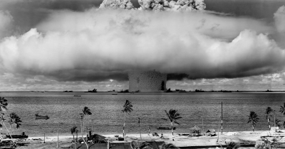
The Bikini Atoll Nuclear Test Site comprises the terrestrial and underwater remains of a military system that characterized the Cold War.
Between 1946 and 1958, 23 nuclear devices were detonated at Bikini Atoll by the USA. The local inhabitants were displaced and the tests had major consequences on the geology and natural environment of Bikini Atoll and on the health of those who were exposed to radiation. It was the start of the ‘nuclear era’, the race to develop increasingly powerful nuclear weapons and it gave rise to international movements advocating nuclear disarmament.
Community Perspective: this site has been unreviewed so far, but it can be reached by live-aboard shipwreck dive trips.
Camino Real

The Camino Real de Tierra Adentro is a 1400km section of the Silver Route stretching from Mexico City to New Mexico in the US.
The route was actively used from the mid-16th to the 19th centuries, mainly for transporting silver extracted from the mines of Zacatecas, Guanajuato and San Luis Potosí, and mercury imported from Europe. The site comprises 60 different locations, including bridges, haciendas, chapels, temples, a hospital and several cities.
Community Perspective: This is an annoying WHS as it repeats 5 components that are already inscribed on their own merits and it lacks the extension into what is now the USA - but local Sinuhe tries to refute these complaints. Among the smaller components, Tepotzotlán, Guadalupe and the Hacienda de San Blas are recommended.
Caves of Yagul and Mitla
The Prehistoric caves of Yagul and Mitla in the Central Valley of Oaxaca are archaeological sites associated with the domestication of plants in North America
Findings in caves and shelters show the transition from hunting and gathering to settled agriculture. In Guilá Naquitz, a wide range of plant food was recovered within the cave deposits, including wild forms of bottle gourd, squash and beans. In other caves, stone tools have been uncovered.
Community Perspective: The main caves are near Yagul (confusingly, the archeological site of Mitla is not part of the WHS). To get into one of the caves you have to hire a local guide. Yagul itself is an interesting archaeological site of the Zapotec civilization.
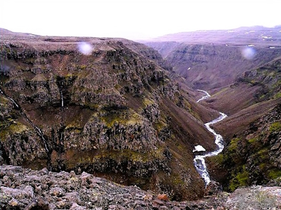
Central Highlands
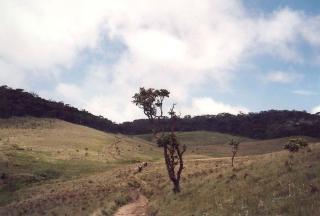
The Central Highlands of Sri Lanka covers the remaining part of its montane rainforests, the habitat of high numbers of threatened flora and fauna species.
The mountainous region covered with grass plains comprises three protected areas: Peak Wilderness Sanctuary, Horton Plains National Park and Knuckles Range. One of the most remarkable surviving fauna species is the endemic Sri Lankan leopard.
Community Perspective: The area’s prime attractions seem to be cultural ones such as the Pilgrimage Path to Adam’s Peak and the surrounding tea plantations, but this is a natural site. You may expect waterfalls and viewpoints.
China Danxia
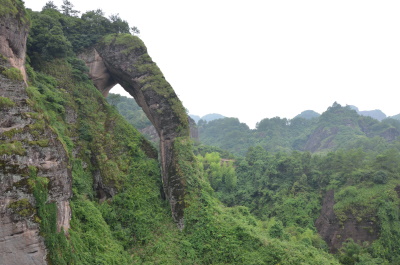
China Danxia comprises landscapes dominated by eroded red sandstone landforms.
The nine components hold examples varying from most to least eroded, where natural pillars, cliffs, and ravines have been shaped by weathering, erosion and tectonic uplift. The Danxia landform is named after Mount Danxia, one of the most famous examples of this landform.
Community Perspective: Both reviewers so far have covered the Danxiashan component, which is accessible via Guangzhou and where the main attraction seems to be the large red phallus stone.
Dengfeng
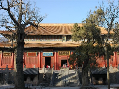
The Historic Monuments of Dengfeng in "The Centre of Heaven and Earth" reflect the tradition of mountain worship.
Mount Songshan was considered the best place for a terrestrial capital according to astronomical observations. A large number of sacred and secular buildings were constructed here, commissioned by Emperors who meant to reinforce their power. They include Buddhist shrines and an astronomical Observatory.
Community Perspective: The globally best-known component is the Shaolin monastery, “the birthplace of Kung Fu”. Juha managed to visit 5 of the other 7 locations, while Zos added a perspective on the Gaocheng Observatory.
Hahoe and Yangdong
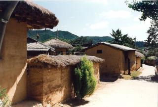
Historic Villages of Korea: Hahoe and Yangdong comprise the two most representative historic clan villages in Korea.
They preserve Joseon-style architecture, folk traditions, valuable books, and the old tradition of clan-based villages. The layout of the settlements followed strict Confucian ideals. They include residences for the head families, mud-walled and thatch-roofed commoners houses and Confucian academies for learning.
Community Perspective: These are peaceful and well-preserved living villages, “with many lovely thatched roof houses, paddy rice fields, lotus ponds and blooming flowers”. They aren’t tourist traps (yet) filled with souvenir shops and restaurants. Clyde managed to stay overnight at the largest hanok, Bukchondaek.
Jantar Mantar
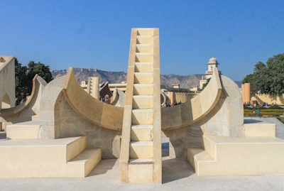
The Jantar Mantar, Jaipur is a collection of large architectural astronomical instruments.
They were built in the new state capital of Jaipur in the early 18th century on the orders of Prince Jai Singh II. He had constructed a total of five such facilities at different locations, including one in Delhi. The Jaipur observatory is the largest and best-preserved of these. It followed the tradition of Ptolemaic positional astronomy and was designed to observe the sky with the naked eye.
Community Perspective: a haven of quiet from the bustling city outside, but it is quite hard to work out how the various instruments worked except for the huge sundial. The separation of this location from the also inscribed Jaipur City seems rather artificial.
Papahanaumokuakea

Papahānaumokuākea is a remote protected area in the Pacific that is important for its island hotspot volcanism and its role in the beliefs of the Native Hawai’ian population.
The area encompasses 140,000 square miles (360,000 km2) of ocean waters and ten islands and atolls of the Northwestern Hawaiian Islands. The multitude of habitats and its isolation have led to high levels of endemism notably among coral and fish species. It is also the habitat of the critically endangered Hawaiian Monk Seal. Significant Native Hawaiian cultural sites such as heiau shrines are found on the islands of Nihoa and Mokumanamana and can be placed within the wider Pacific/Polynesian tradition. There are also locations of historic shipwreck sites.
Community Perspective: the site is essentially closed to tourists, only Midway Atoll National Wildlife Refuge has been accessible in the past (until 2012) via a special visitor program as described by Zoë.
Phoenix Islands
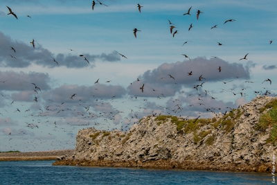
The Phoenix Islands Protected Area is a remote marine ecosystem known for its high biodiversity and exceptional beauty.
The site has experienced minimal human impact and profits from outstanding underwater clarity. The oceanscape consists of numerous large submerged volcanoes (seamounts), eight atolls which are important refuges for seabirds, and two submerged coral reefs. The property is also of crucial importance for the scientific study of marine ecosystems of the Pacific.
Community Perspective: this site has been unreviewed so far.
Pitons of Reunion
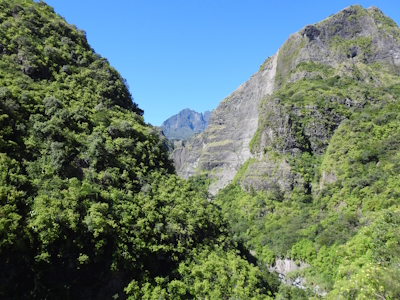
The 'Pitons, cirques and remparts' of Reunion Island are renowned for their visually striking landscape and remaining high numbers of endemic plant species.
The site consists of two adjoining volcanic massifs, with remparts (steep rock walls) and the three cirques (imposing natural amphitheaters) of Salazie, Mafate et Cilaos that evolved due to erosion and volcanism. The Pitons are covered with subtropical rainforests and cloud forests.
Community Perspective: Kbecq has described the four tough hikes he did here on volcanic terrain, while Els hiked into the Cirque de Mafate.
Putorana Plateau
The Putorana Plateau is a vast, remote and pristine Arctic landscape.
The area holds a complete set of subarctic and arctic ecosystems like taiga, tundra and arctic desert, alternated with lakes, rivers and deep canyons. It is mostly covered by permafrost. Twice a year, migrating reindeer cross the property.
Community Perspective: Martina did an epic week-long trip to this site in Siberia, and has shared the practical details and the experience.
Safi al-Din Ensemble in Ardabil
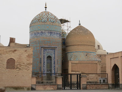
The Sheikh Safi al-Din Khanegah and Shrine Ensemble in Ardabil is a Sufi spiritual retreat dating from the 16th-18th centuries.
It is the burial site of Safi al-Din Ardabili, the eponymous founder of the Safawiyya order of Sufism, and an important site of pilgrimage. The complex is a fine example of Ilkhānid and Timurid- influenced Iranian architecture and one of the most beautiful of all monuments from the Safavid era. It also served social and eductional purposes, and includes a library, a mosque, a school, a hospital, kitchens, a bakery and some offices.
Community Perspective: The interior of the shrine is the best part, with blue and gold ornamented tiles and overall delicate decoration. The Porcelain Room, with niches filled with precious Chinese porcelains, is one of its highlights.
São Francisco Square
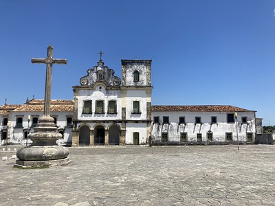
São Francisco Square in the town of São Cristovão is an open space surrounded by a monumental architectural ensemble.
It combines the urban planning ideas of Portugal and Spain, as the square originates from a time when Portugal and Spain were under the same crown. The concept of a Plaza Mayor was taken from Spanish colonial cities. The most prominent monuments around the square are São Francisco Church and Convent (begun in 1693), Church and Santa Casa de Misericordia (18th century), and the Provincial Palace.
Community Perspective: Due to its Spanish roots it’s unique in Brazil, but that’s about it and there is little tourist infrastructure. Best reached from the coastal city of Aracaju.
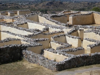
Sarazm
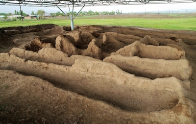
The Proto-urban Site of Sarazm comprises the archaeological site of an ancient settlement along a major trans-Eurasian trade route.
It had connections to Central Asia, Mesopotamia and the Indus civilizations. From the Bronze Age onward, its agricultural and trading activities were extended to metallurgy (tin and copper) and handicrafts. It was abandoned around 2000 BCE.
Community Perspective: a low-key site with a tiny on-site museum, that takes an hour to visit at most. It can be reached from the Tajik town of Penjikent (by taxi or your own transport), or more easily since 2019, as a “country hack” day trip from Samarkand (Uzbekistan) as described by Zoë and Nan.
Tabriz Bazaar
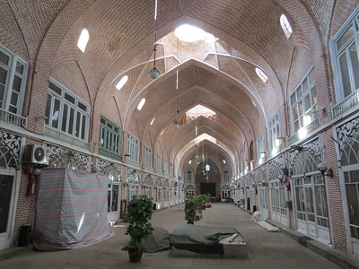
The Tabriz Historic Bazaar Complex is an example of commercial architecture with a number of specialized buildings.
Tabriz was located on a centuries-old east-west trading route. The Bazaar flourished mainly between the 12th and 18th centuries. During that era, Tabriz became the capital city of the Safavid kingdom and remained an important commercial and economic center afterward.
Community Perspective: This covered bazaar is one of the world’s largest. Besides numerous shops (which feel quite modern), you can find more than 20 caravanserais and a Friday Mosque in its interior. To “add value” to the visit experience it is worth trying to understand and chase down the different social and architectural elements of the Bazaar as described in the AB evaluation and the nomination file.
Thang Long

The Central Sector of the Imperial Citadel of Thang Long-Hanoi is the archeological site of the old capital of Vietnam, which originated in 1010.
This makes it one of the oldest continuous centers of power in the world. It is directly associated with cultural and historical events in this independent nation for more than a thousand years. Its structures show a unique synthesis of the influence of various Asian cultures.
Community Perspective: The site has essentially been off-limits to outsiders until 2010, as it was in military use. It lies in the center of Hanoi but is not well-signposted. When you read the reviews in chronological order, you’ll notice that the site gradually is opening up and has more ‘on show’ for visitors.
Turaif Quarter
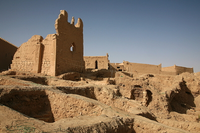
The At-Turaif District in ad-Dir’iyah encompasses the remains of a traditional human settlement developed in a desert environment, dating from the 15th century.
ad-Dir’iyah was the original home of the Saudi royal family, served as the capital of the first Saudi dynasty from 1744 to 1818 and is associated with the the spread of Salafism. Its remains consist almost entirely of mud-brick structures including palaces. They are a unique example of the Najdi architectural and decorative style developed to cope with the extreme desert climate.
Community Perspective: Most reviewers so far have been limited to external views, as the site has laid untouched for a long time and only recently became the focus of major restoration works. From 2023 on, the site has become accessible (and seems worth it!) but it needs prior booking.
Extended Sites in 2010
Churches of Moldavia
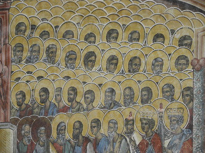
The Churches of Moldavia comprised eight Byzantine churches with painted exterior walls.
These paintings systematically cover all the facades with cycles of Orthodox Christian religious themes. The churches were built between ca. 1487 and 1532, as a protective barrier against the Muslim Ottoman conquerors from the East and during a period of cultural flowering of the newly independent state of Moldavia.
Community Perspective: these painted churches are in the highest category of WHS in Europe. You can easily spend a day or more driving between them.
Solivagant UK - 15-Jun-05

Romania has inscribed 3 different “sets” of churches on its WHS list. Each set exists in a separate geographical area of the country and each is distinguished by a different architectural feature - Wooden, Fortified and Painted. We have only visited the latter 2 and, on the basis of their uniqueness, beauty and situation would place the Painted Churches among the highest category of WHS in Europe. A visit to them is really a wonderful experience.
The churches are mainly, but not all, set within “Monasteries” (though, as these all seemed to be “staffed” by Nuns when we were there, I wonder whether “Nunnery” might not be a more correct description!) [...]
Read OnCoa Valley and Siega Verde
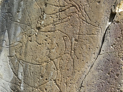
The Prehistoric Rock Art Sites in the Côa Valley and Siega Verde are representations of Palaeolithic art and the life of our early ancestors.
The rock engravings were made on cliffs in the open air along the Côa and Águeda river valleys. They depict mainly animals. The oldest engravings date from the Upper Palaeolithic (22,000-10,000 BCE).
Community Perspective: Go in the cooler months as it can get hot out there. Some of the Portuguese and Spanish components can be reached via official guided tours, and good explanations are provided on those. The engravings are “hard to appreciate without a magnifying glass and good sunlight.”
Werner Huber Austria - 01-May-05

We visited the WHS of the rock drawings as part of our trip through northern Portugal. The drive up the Douro Valley is beatiful anyway but I wouldn't have gone that far if there was no WHS.
We had prearranged a tour with the park rangers and the Coa Valley turned out to be a beautiful and tranquil place. There were no tourists there whatsoever, good on one hand but whether the park will ever be able to economically justify itself, is doubtful.
I have to admit that a good bottle of vinho verde attracts me slightly more than most of the rockdrawings we finally saw
Read OnGraz
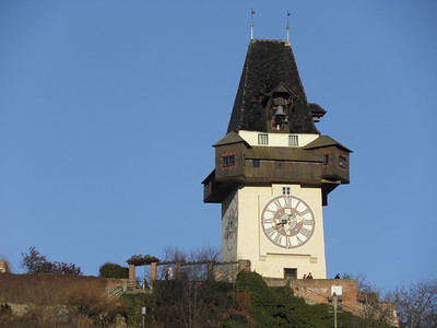
The City of Graz - Historic Centre and Schloss Eggenberg comprises an ensemble of typical buildings from different epochs and in different architectural styles.
Being situated in a cultural borderland between Central Europe, Italy and the Balkan States, Graz and with the patronage of the Habsburgs, Graz absorbed various influences from the neighbouring regions. Today the old town still holds many monumental buildings, their age ranging from Gothic to Contemporary. At its western edge lies the baroque Eggenberg Castle.
Community Perspective: a beautiful centre with lots of interesting sites but without the crowds of Vienna or Salzburg. Ian's review gives a good overview of how to spend 24 hours in the city.
Klaus Freisinger Austria - 01-May-05
Austria's second-largest city has a beautiful centre with lots of interesting sites (the Zeughaus has the world's largest medieval armoury), but without the hordes of tourists that crowd Vienna or Salzburg. There are buildings from several epochs, which can be seen from above from the Uhrturm (clock tower), the city's landmark. The site was recently expanded to include Eggenberg Palace, a very pretty late-Renaissance building a short tram ride from the centre. It has a large garden with an interesting archaeology museum, and is certainly a worthy addition to the site.
Read OnMonte San Giorgio
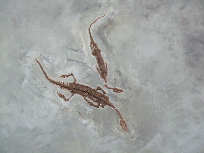
Monte San Giorgio is a mountain at Lake Lugano known for its marine fossils from the Mid-Triassic Period.
At that time (about 240 million years ago), the area had a tropical climate and a sea full of coral, fish, (long-necked) reptiles and turtle-like creatures. Fossils of these animals were found well preserved in what had been a sea basin. The quality of preservation is very high, a number of 'first discoveries' of species have been made here and the site has been studied for a long time.
Community Perspective: The museum in Meride is a worthwhile start, as it holds several fossils found at the site. There’s a trail that starts just outside Meride to take you into the core zone and to the top of Monte San Giorgio.
Els Slots The Netherlands - 01-Jun-08

As this is the first review of Monte San Giorgio at this website, and because it's not your run-of-the-mill tourist attraction either, I had to start from scratch in finding out how to 'visit' it. My conclusion after many hours of Googling is that there are two ways: by car 'from the back' or via a combination of boat and cable car 'from the front'. Visiting is a relative aspect here anyway - the IUCN reports of "boundaries (..that..) cannot be traced in the field". This site is all about fossils that have been taken away to museums a long time ago.
Read OnNgorongoro

The Ngorongoro Conservation Area is centered around the Ngorongoro Crater and the hominid fossils found in the Olduvai Gorge.
The crater floor is the world's largest unbroken, unflooded volcanic caldera. Its grassy plains with both fresh and brackish water lakes provide a natural enclosure for a very wide variety of wildlife. Ngorongoro is also part of the annual Serengeti migration route of wildebeest and other ungulates. With Laetoli, where fossilized footprints have been found, and remains of a number of diverse hominin species within the Olduvai Gorge, the site also has contributed to the study of human evolution.
Community Perspective: This covers a large area that extends well beyond the crater into the Lake Ndutu area and Olduvai Gorge; their features are well-described by Squiffy.
Brandon Davis United States - 01-May-05
I recently visited Tanzania on safari for my honeymoon. We visited in early July and spent almost two weeks there. On our travels we visited the Ngorongoro Conservation Area. It was amazing. Although we were there during the dry season and everything wasn't as lush as in pictures I had seen, it was beautiful. The weather was cool to cold along the rim, but inside the crater it was perfect weather for safari. Because of it being the dry season the tsetse flies were minimal and mosquitos were not a problem. We saw lions, hyenas, black-backed and common jackals, elephants, DeFassa's waterbuck, vervet monkeys, baboons, plenty of hippos, wildebeast, zebra, Thomson and Grant gazelle, flamingo, three species of eagles, various water birds, buffalo, and four black rhino
Read OnPirin National Park
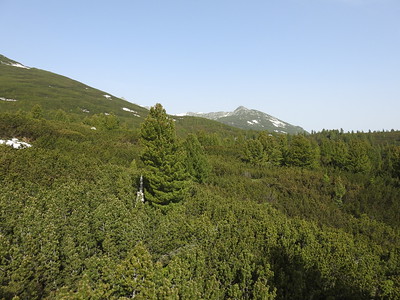
Pirin National Park is renowned for its remote mountain scenery and glacial geomorphology.
The park comprises the undeveloped part of the Pirin mountain range, which is covered with alpine meadows and coniferous forests. Its glacial features include cirques, deep valleys and over 70 glacial lakes. The park is also noted for its variety in flora, including the Edelweiss, 300 species of mosses and algae.
Community Perspective: This is close to a major ski area (that’s essentially the buffer zone), and even when hiking in Spring you will encounter snow on or near the trails (see the reviews of Nan and Els). Solivagant has summarized its qualities nicely: "It contains attractive, if unremarkable, mountain scenery which will provide a pleasant escape from civilisation and interesting hiking opportunities.", although the many glacial lakes must be given special mention (Hubert visited several of them).
Solivagant UK - 21-Feb-06

“Natural WHS” seem to me occur in 2 categories – sites with a visible “Wow factor” in the form of some (near) “world unique” geological or wildlife sight which makes them worth undergoing a long journey to see (eg Grand Canyon or Bwindi), and those which, for reasons of remoteness, government action or luck have largely escaped the depredations of man and remain in a reasonably pristine state to demonstrate what some particular ecological niche or climatic zone once looked like
Read OnRammelsberg and Goslar
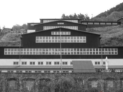
The Mines of Rammelsberg, Historic Town of Goslar and Upper Harz Water Management System constitute of one of the largest mining and metallurgical complexes for non-ferrous metals in Europe.
The Rammelsberg mining complex has an over 1,000 years long, continuous history of mining and metal production. The technological ensemble includes both surface and underground remains, including those for the management of water for drainage and power. The nearby town of Goslar achieved great prosperity in the late Middle Ages thanks to the revenues from mining, metal production and trade. It also played an important role in the Hanseatic League.
Community Perspective: Ian enjoyed a Christmassy Goslar, while Hubert has focused his review on the later addition of the Upper Harz Water Management system. The Rammelsberg mines can be visited by guided tours, of which Kbecq took two.
Ronald Wells United Kingdom - 01-May-05
For anyone remotely interested in industrial archeology or geology the Rammelsberg mine is a must-see. When you approach the site and see the array of processing buildings stretching up the mountainside it is clear this is no ordinary mine relic. It dates from the 10th century and worked with few interruptions until 1988. Many of the early features survived and it is fortunate that closure took place when the social value of such places was recognised so that everything has been preserved even the miners' clothing, each man's hanging from its own ceiling hook just as it did the day it closed.
Read OnRøros

Røros Mining Town and the Circumference comprises a relict mining town and industrial landscape shaped by copper mining.
Within the Circumference, a privileged area within a 45km radius around town, Røros Copper Works held the monopoly to exploit the natural and human resources. The workers lived in Røros Town, which was fully made of wood. Work was done under severe climatic conditions, and ways were found to adapt to it for example via the 'Winter Transport Route' on frozen lakes and rivers.
Community Perspective: this still is a fairly remote site and on public transport, you will not be able to see the outlying components (no reviewer so far seems to have visited by private car). Els describes what a guided tour of the town entails and there are tantalizing videos by André and Joel. Be aware that in summer the site can get very busy with Norwegian daytrippers.
John booth New Zealand - 03-May-10

I visited Roros on a day trip by train from Trondheim. The train journey involved a steep climb, with a substantial drop in temperature, even in August.
The town was compact enough to visit all the significant features like the smelting area, slag heaps and workers' cottages on foot, interspersed with visits to the several hot soup kitchens available.
The construction of the houses was of great interest to me, with the walls made from rough hewn logs with interlocking joints at the corners and grass growing in a layer of topsoil on top of the shingle roofs.
Read On