Bam Cultural Landscape
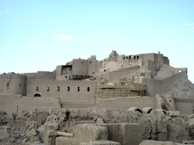
Bam and its Cultural Landscape is an outstanding example of a medieval Central Asian trading settlement in a desert environment.
The site consists of a fortified mud-brick citadel (Arg-e Bam) with part of the old town within its walls, and the surrounding countryside including other settlements and medieval structures such as mausolea. An elaborate underground water management system (the qanâts) is still in use today, together with its supporting social system.
Community Perspective: "In its current state, it really is not particularly exciting" - traces of the 2003 earthquake were still everywhere when our two reviewers so far, Jarek (2010) and Alexander (2016) visited. Many parts were closed for visiting or looked after by indifferent guards.
Cape Floral Region
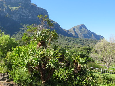
The Cape Floral Region Protected Areas consists of 13 clusters covered with fynbos and known for their rich plant life.
They are located in the Mediterranean climate region of South Africa Western Cape Province and the Eastern Cape Province. With the Cape Floral Region being of the six Floral Kingdoms of the world, the outstanding diversity, density and endemism of the flora are among the highest worldwide.
Community Perspective: The site comprises 13 locations, of which Table Mountain and the Kirstenbosch Gardens are the most accessible as they lie in Cape Town. Bernard has given an overview of some other clusters that can be done self-driving. August/September is the best time to see the flowers.
Champaner-Pavagadh
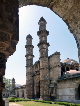
The Champaner-Pavagadh Archaeological Park comprises an early Islamic, pre-Mughal city and its architecture shows the transition between the Hindu and Muslim traditions.
This largely unexcavated city which has been built in the 16th century was the short-lived capital of Gujarat. Spread across 12 locations on a hill, a large number of monuments, including fortifications, water installations and different standing structures remain. Among them is the Great Mosque, which became a model for later mosque architecture in India. The site is still a place of pilgrimage for Hindus who visit the earlier temple of Kalika Mata.
Community Perspective: Pavagadh Hill is where the Hindu pilgrims congregate, while Champaner comprises the remains of the Islamic fort, palace and mosques. “It has been inscribed for 13 years now. The slums are still inside the archeological park, the trash keeps piling up and we get charged 600 rupees for two mosque entries.” – as Zoë summarizes it. Solivagant explains how this all happened.
Chhatrapati Shivaji Terminus
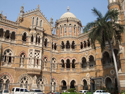
Chhatrapati Shivaji Terminus (formerly Victoria Terminus) is a 19th-century railway station known for its architectural mix of Victorian Gothic Revival and traditional Indian features.
The station is a symbol of the blossom period of Mumbai as a commercial port city in the late 19th century. The design of the building, by the hand of British colonial engineer Frederick William Stevens, is characterized by the use of turrets, pointed arches and colouring.
Community Perspective: “It looks more like a decorated palace or a cathedral than something as mundane as a transport depot.”, however, it still is a (very) active railway station. There is not a great deal to see beyond the exterior, as large parts of the building are closed off for offices etc (but you may try to sneak in as Ian did or book a Heritage Tour like Clyde).
Etruscan Necropolises
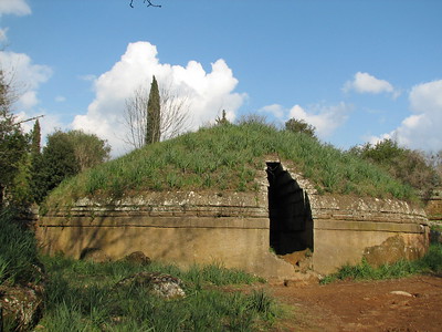
The Etruscan Necropolises of Cerveteri and Tarquinia bear witness to the achievements of Etruscan culture, the first urban culture in the western Mediterranean.
They are the remains of two ancient Etruscan city-states, dating back to the 9th and 7th century BCE respectively. The frescoes in the tombs of Tarquinia show the daily life of the Etruscans, while the cemeteries of Cerveteri represent Etruscan town planning.
Community Perspective: The interior of 16 of the tombs at Tarquinia can be visited (albeit you have to watch the paintings from behind a glass door). At Cerveteri, the tombs are still covered under mounds which are overgrown with grass and shrubs. Here the attraction lies in walking around the ‘streets’ of the cemetery. Nan found a way around closed doors and limited public transport. And James reported that even in 2022 this is a cash-only site.
Grimeton Radio Station
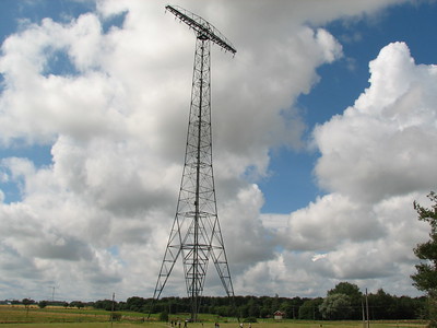
The Grimeton Radio Station, Varberg holds an ultra-longwave radiotelegraph transmitter that was used for wireless transatlantic communication in the 1920s.
The site consists of transmitter equipment, including the aerial system with six 127 m high steel towers, and a neoclassical residential area with housing for the station staff. The Varberg station is the only one left from a global network that was planned after WWI to enhance communication between countries worldwide.
Community Perspective: although you can access the site at all hours, joining one of the guided tours is recommended to fully understand its workings.
Ilulissat Icefjord
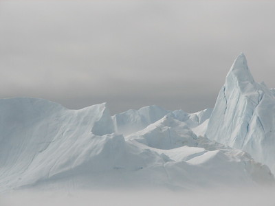
The Ilulissat Icefjord is the outlet of the pre-eminent glacier in the northern hemisphere, globally only surpassed by Antarctica in terms of size and calving.
The site consists of Sermeq Kujalleq, the most productive glacier draining the inland icecap on Greenland, and the iceberg-filled tidal fjord named Kangia. The glacier has been a long-time object of scientific study and has significantly added to the understanding of ice-cap glaciology, climate change and related geomorphic processes.
Community Perspective: this stunningly beautiful area can be explored on foot, by boat or by helicopter, and it takes several days to take in its many features. Be aware that this destination doesn’t come cheap. And that the spectacularly calving Eqi glacier mentioned in some of the reviews is outside of the core zone.
Kernavė
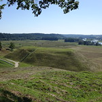
Kernavė Archeological Site (Cultural Reserve of Kernavė) comprises the remains of human settlements, burial sites and five hill forts from the late Palaeolithic Period to the Middle Ages.
The findings show evidence of the pre-Christian heritage of the region (especially its funeral traditions) and the subsequent conversion to Christianity. The hill forts were a 14th-century addition and made use of the earlier mounds for the defense system.
Community Perspective: there’s an on-site museum and you can climb the unexcavated hills, but don't expect to see any grand ruins.
Kii Mountain Range
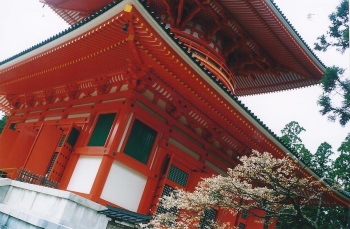
The Sacred Sites and Pilgrimage Routes in the Kii Mountain Range are testimony to the indigenous Shinto belief and its fusion into Shinto-Buddhism.
These three sacred sites with Shinto shrines and Buddhist temples lie in the forests of the sacred Kii Mountains. They have attracted pilgrims since the 11th century. Their architecture has had a profound influence on the building of temples and shrines elsewhere in Japan.
Community Perspective: Koyasan is the most visited component, and one can easily arrange a temple stay here. John went to all three main sites, and Frederik, Hubert and Nan ‘did’ Yoshino which lies close to Nara.
Koguryo Kingdom
The Capital Cities and Tombs of the Ancient Koguryo Kingdom represent an exceptional testimony to the vanished Koguryo civilization.
These archaeological sites comprise their first three capitals and 40 tombs. The imperial tombs have a stepped pyramid form, while the tombs of the nobles are decorated with wall paintings that depict scenes from daily life. Stele and inscriptions at the sites show the impact of Chinese culture on the Koguryo.
Community Perspective: Zoë liked Wandu Mountain City best and has written an overview of what you can see on a 3-hour visit.
Koguryo Tombs
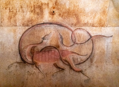
The Complex of Koguryo Tombs with its beautiful wall paintings represents the burial customs of the Koguryo Kingdom.
The monumental stone tombs were built under earthen mounds. Different types existed, varying in the number of burial chambers inside. The richest were decorated with wall paintings, showing scenes of Koguryu culture such as food, costumes and religious practices. The Koguryo Kingdom stretched from the northeast of China to the northern and central parts of the Korean Peninsula from ca. 37 BCE – 668 CE.
Community Perspective: Although tombs may be a staple on standard North Korean itineraries, seeing one of these specific examples may require putting in a “special request”. Solivagant and AC both visited the heavily reconstructed Tomb of King Tongmyung and were not allowed inside.
Koutammakou
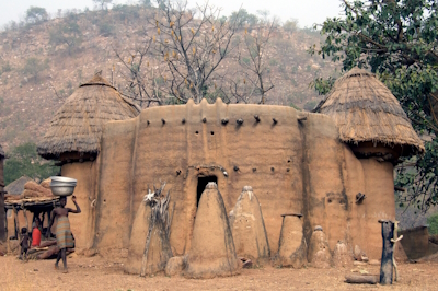
Koutammakou, the land of the Batammariba, represents a traditional way of settlement known for the architecture of mud “takienta” tower houses.
Most of these buildings have two stories, and either flat or conical thatched roofs. They combine domestic functions with space for animals and granaries. Koutammakou also is a living cultural landscape where the agricultural society lives in harmony with the surrounding nature. This is expressed in sacred forests, rocks and intangible elements.
Community Perspective: a highlight of a trip to Togo, where a local guide with appropriate knowledge, contacts and language is absolutely essential. Solivagant visited villages in both Togo and Benin, the latter proving "a more fruitful area for exploration and interaction with the Battamariba".
Luis Barragán House and Studio
The Luis Barragán House and Studio represents the late phase of the International Modern Movement in architecture, where these ideas were applied regionally.
Luis Barragán created an innovative architectural style that combined Modernism with the colonial and prehispanic architecture of Mexico and with that of the Mediterranean. His work has influenced the design of gardens and urban architecture in the Americas in the 20th century. His house and studio were built in 1948 in Mexico City.
Community Perspective: This site gets mixed reviews – some really love it (Ian), for others, it didn’t live up to the hype or it raised essential questions (Solivagant). A visit however never seems to leave the visitor untouched; just read through all the reviews. You have to pay significantly extra to take pictures inside: Clyde’s review gives a taste of what it looks like.
Madriu-Perafita-Claror Valley
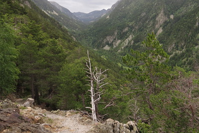
The Madriu-Perafita-Claror Valley is a pastoral landscape reflecting an agricultural way of life that was once widespread in the upland regions of Europe but now survives only in this part of the Pyrenees.
The valley was a place of passage with tracks linking it to France and Spain. Shepherds, charcoal burners, miners, blacksmiths, farmers and even smugglers have used these footpaths over the centuries. It corresponds with the Madriu river basin. The highest part is a glacial landscape, the rest was and still is used as pastures for the grazing of cows and horses during the summer. The two settlements within the valley are only used in the summer months. Terraced fields have been constructed to grow rye, and wheat and to provide hay. The land is communally owned.
Community Perspective: A number of marked trails lead into the area. But as beautiful as the scenery might be, it will not bring you closer to understanding the cultural value and one reviewer even wondered how alive the pastoral tradition really is.
Mazagan

The Portuguese City of Mazagan (El Jadida) is a fortified port city on the Atlantic coast that was designed by the Portuguese on their way to India.
The Portuguese built a citadel here in 1514 and enlarged it into a fortification in 1541. They also constructed 4 churches within the fortification. The remaining buildings from the Portuguese period are the cistern and the Manueline Church of the Assumption. After the departure of the Portuguese, the city remained uninhabited until the mid-19th century.
Community Perspective: It’s a small, compact area with no spectacular sights, but a walk on the walls and the underground cistern are worth it.
Medieval Monuments in Kosovo
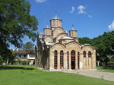
Medieval Monuments in Kosovo comprises four Serbian Orthodox Christian churches and monasteries built in the 13th and 14th centuries.
They represent the development of the fusion of the eastern Orthodox Byzantine and the western Romanesque ecclesiastical architecture to form the so-called Palaiologos Renaissance style. It has a distinct style of mural painting of which rich examples can be seen in these churches, culminating in Gračanica.
Community Perspective: these are small Serbian-Orthodox enclaves within the territory of Kosovo, so be aware of the current Serbia-Kosovo political situation. The easiest one to reach on public transport is Gracanica, close to the Kosovan capital Pristina.
Muskauer Park
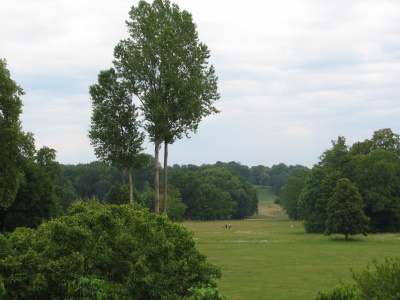
Muskauer Park / Park Mużakowski is a 19th-century landscape park that has been influential in landscape architecture.
The founder of the park was Prince Hermann von Pückler-Muskau, who developed the park initially on the grounds of its estate and then extended it to reach the town of Bad Muskau. He incorporated human-made architectural elements into a network of vistas along with natural components.
Community Perspective: The park now lies on both sides of the German/Polish border at the river Neisse in a fairly remote location. It requires a lot of walking to see it all, so it’s better to rent a bike. The buildings (Old and New Castle) are not that impressive. Pückler was a very avid early traveller, and he even has his own connection!
Novodevichy Convent
The Ensemble of the Novodevichy Convent is the best-preserved representative example of the "Moscow Baroque" style in Orthodox architecture.
The convent had a symbolic and physical relationship with the Moscow Kremlin, the "Tsar's road" linking the two complexes. In this nunnery, in the 16th and 17th centuries, women from the royal family and top-ranking families took the veil. The walled complex consists of 14 buildings with rich interiors, surmounted by golden domes.
Community Perspective: A serene place (though often visited), that can be easily reached from central Moscow on the Sportivnaya metro station. Due to serious fire damage in 2015, much of it remained under scaffolding until at least 2018. A more recent review is lacking.
Orkhon Valley
The Orkhon Valley Cultural Landscape is a tribute to Mongolia's culture of nomadic pastoralism and the way it eventually supported trade networks and empires.
The Valley’s steppe landscape has been home to a succession of nomadic cultures since Prehistory. The area includes the remains of Kharakhorum, the 13th and 14th-century capital of Chinggis Khaan's vast Mongolian Empire, Buddhist monasteries like Erdene Zuu where Mongolia’s form of Buddhism developed, and Khar Balgas, a former capital of the Uighur Empire.
Community Perspective: probably more memorable for its landscape dotted with “gers (yurts) and the herds of horses, yak and camels of nomad families” than its archeological remains. The restored Erdene Zuu however is one of Mongolia’s major tourist attractions, and it has been visited by all reviewers. Michael managed to fit in the Uygur site of Khar Balgas and the relatively new Karakorum Museum as well.
Pasargadae
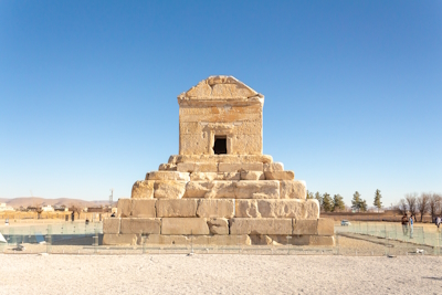
Pasargadae covers the archaeological remains of the first capital of the Persian Empire, dating from the 6th century BCE.
Its most important monument is the tomb of Cyrus the Great, the founder of the Achaemenid Empire who went on to conquer much of Western Asia. Pasargadae’s gardens provide the earliest known example of the Persian chahar bagh, or fourfold garden design. The complex further consists of other examples of royal Achaemenid architecture such as a fortress, palaces (‘the royal ensemble’) and a 14m high stone tower.
Community Perspective: The site is much larger than the iconic tomb alone and you can easily spend 2 hours here, although the remains of the palaces etc don’t go much further than a floor plan or a tell and it looks ‘empty’. You can drive between the parts or take a shuttle.
Pico Island
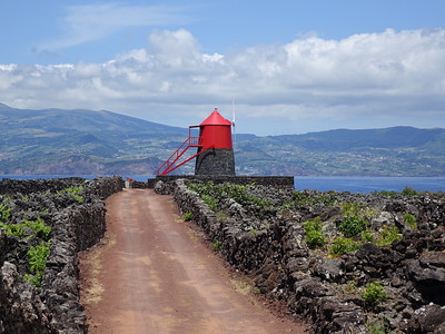
The Landscape of the Pico Island Vineyard Culture is the result of the agricultural practice of viniculture on a small volcanic island since the 15th century.
The area comprises two thin coastal strips that were adapted to growing vines on land unsuitable for other arable cultivation. The small-scale farmers created thousands of stone-walled fields for their crops. Cellars, distilleries and warehouses for wine production are also included.
Community Perspective: The pretty island of Pico is part of the Azores and can be reached by domestic flight. Visiting the site can be easily done by car or on walks from Magdalena. In Lajido de Santa Luzia you'll find the Vineyard Culture Interpretation Centre.
Pitons Management Area
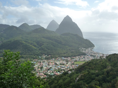
The Pitons Management Area is a stunning volcanic landscape that provides a prominent landmark across Saint Lucia and its surrounding sea.
This collapsed stratovolcano consists of two lava domes or volcanic plugs: the Gros Piton is 771 m, and the Petit Piton is 743 m high; they are linked by the Piton Mitan ridge. The area features various volcanic features, like sulphurous fumeroles, hot springs, explosion craters, pyroclastic deposits (pumice and ash), and lava flows. Combined with the backdrop of lush and diverse natural tropical vegetation it is considered of exceptional natural beauty. The site also includes a strip of marine reserves.
Community Perspective: the site can be explored in a number of ways – ranging from climbing its peaks to a day tour by car, a visit to the tourist-trappy Sulphur Springs, and snorkelling.
Royal Exhibition Building
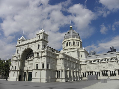
The Royal Exhibition Building and Carlton Gardens represent the late 19th-century international exhibition movement, showcasing technological innovation and change that was made possible by the industrialisation.
The building consisted of a Great Hall of Industry of over 12,000 square metres and many temporary annexes in the Gardens. It presented Australian industry and technology to the world during the Melbourne International Exhibition of 1880 and the 1888 Melbourne Centennial International Exhibition. The formal Carlton Gardens also were characteristic of exhibition buildings of this period.
Community Perspective: Try to book one of the guided tours to the interior (see Clyde’s review), otherwise you may leave disappointed.
Tanbaly
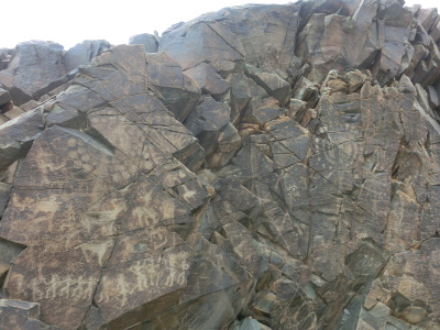
The Petroglyphs within the Archaeological Landscape of Tanbaly testify to the lives and beliefs of the people of the Central Asian steppe since the Bronze Age.
Tanbaly holds large petroglyphs, mostly cut into unsheltered rock faces, that are unique in their iconography. Over 5,000 images across 48 locations have been found. The site also includes ancient settlements, burial sites and sacred sites.
Community Perspective: situated in a remote location, only accessible via private transport. The rock engravings are signposted in 5 or 6 groups, and can be easily visited in 2 hours. Solivagant’s review zooms in on the cultic complex that they allegedly were part of.
Thingvellir
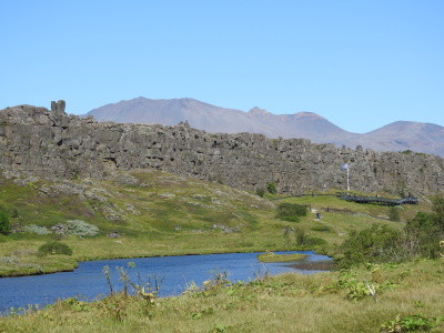
Thingvellir National Park is a Norse/Germanic archaeological site containing the remains of the place where the Alþing met in the Middle Ages.
Once a year, residents from all over Iceland gathered here in the open air for two weeks to make judicial and administrative decisions. The site continues to have an iconic status for the national Icelandic identity. It is located in an impressive natural volcanic setting, and on the Mid-Atlantic Ridge that separates the North American and Eurasian continents.
Community Perspective: although being one of the most geologically fascinating sites globally, it was only inscribed on cultural criteria. The relationship between the natural and cultural aspects of the site stays somewhat intangible. The site is easy to reach as it is part of the Golden Circle, but “don't do one of the tour bus trips from Reykjavik. Renting a car and allowing yourself a full day here is worth it”.
Tomb of Askia

The fifteenth-century Tomb of Askia in Gao is a fine example of the monumental mud-building traditions of the West African Sahel.
It is believed to be the burial place of Askia Mohammad I, the first Emperor of the Songhai Empire, which once controlled the lucrative trans-Saharan trade from West Africa. The complex includes the pyramidal tomb, two mosques, a cemetery and an assembly ground. It receives a regular renewal of the layer of plaster, which erodes each winter.
Community Perspective: located in a region with long-standing security issues, the site has only been reviewed once so far. Werner visited on a day trip in 2011.
Town Hall and Roland, Bremen
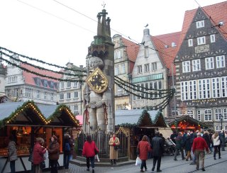
The Town Hall and Roland on the Marketplace of Bremen represent the civic autonomy and market freedom during the Holy Roman Empire.
The Town Hall and statue of Roland are prominently placed on the market square of the Hanzestadt Bremen. Roland statues can be found in a number of German towns, they represent market rights and freedom. The Old Town Hall was built in 1409 in Gothic and was renovated in the 17th century in the Weser Renaissance style. It was specially designed to act as a Town Hall and was used until the early 20th century.
Community Perspective: Bremen overall comes out as quite pleasant (the Böttcherstrasse is recommended), but you wouldn’t go there only for its Town Hall (of a type common in the Low Lands) and heavily reconstructed Roland. Do take a guided tour of the interior of the Town Hall.
Tropical Rainforest Sumatra

The Tropical Rainforest Heritage of Sumatra is a mountainous landscape that holds the most important remaining forests on the island.
The site comprises three national parks on the Bukit Barisan range: Gunung Leuser National Park, Kerinci Seblat National Park, and Bukit Barisan Selatan National Park. Their diverse ecosystems include volcanic, coastal and glacial features, often of great beauty. The forests hold many endangered species including the endemic Sumatran orang-utan, Sumatran tiger, rhino, elephant and Malayan sun-bear.
Community Perspective: Gunung Leuser is the most accessible of the parks, and its Bohorok entrance is suited for day visits. Clyde stayed for 4 nights camping (“Sleeping in the tropical rainforest/jungle was a nightmare”) inside the park and encountered over a dozen orangutans who once were rescuers. Timonator ponders about the ethical aspects of the tours conducted from Bukit Lawang.
Um er-Rasas
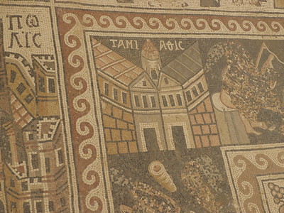
Um er-Rasas (Kastron Mefa'a) is the archeological site of an important Christian monastic and pilgrimage center.
In the 8th century, there were at least 16 churches here, and pilgrims travelled from afar to see and consult the Stylite monks that lived on stone towers. One of those towers (14m high) is still standing. Noteworthy also is the mosaic floor of the Byzantine Church of Saint Stephen with its representation of towns in the region.
Community Perspective: You’d come here for the mosaics, which are well-preserved and protected from the sunlight by a kind of “hangar”, and the one remaining Stylite tower which lies about a kilometre away. Squiffy has written a comprehensive review about what you may expect.
Val d'Orcia
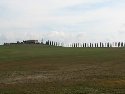
The Val d'Orcia is a cultural landscape from the Renaissance comprising an aesthetically pleasing combination of farmlands and fortified villages on hilltops.
The landscape as it unfolds nowadays was created as an investment by wealthy Siennese merchants in the 14th and 15th centuries. The farmers cultivated mainly grains, vines and olives, and had to share part of their revenue with the merchants as rent. The beauty of the area inspired Renaissance painters and early travellers on the Grand Tour alike.
Community Perspective: It’s quintessentially Tuscan, with hills, olive trees and rows of cypresses. It’s best to just drive around and take it all in. A few reviewers have named highlights such as Bagno Vignoni (Tsunami), the Cipressi di San Quirico d'Orcia (Frederik), and the Romanesque Abbey of S Antimo (Matejicek).
Vegaøyan
Vegaøyan – The Vega Archipelago represents a cultural landscape near the Arctic Circle shaped by farmers and fishermen.
The Vega islands have been inhabited since the Stone Age. People make a living based on fishing and the unique practice of eider down harvesting – a practice that has survived since the 9th century. The farmers built nests for the wild eider ducks that arrive in the breeding season and gathered the valuable eider down in return after the birds left.
Community Perspective: the eider ducks arrive in Spring, but tourists aren’t welcome then. You’ll have to make do with the eider duck museum near Holand or the new World Heritage Center in Gardsøy to get the idea. Nan has described the different ways to get to the archipelago. Also, be aware that the core zone of this site is limited to the west of the main island and the surrounding seascape.
Wrangel Island
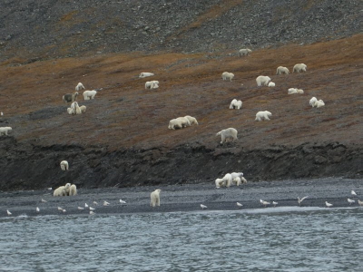
The Natural System of Wrangel Island Reserve comprises a group of two islands north of the Arctic Circle with a remarkably high diversity of plants and animals.
Wrangel Island and Herald Island lie in the High Arctic Tundra ecoregion, with a very dry and cold climate and a mountainous landscape. The islands were not glaciated during the last Ice Age and subsequently served as a refuge for Pleistocene species that have not survived elsewhere. Biodiversity is high considering its location, with a large breeding Snow goose population, up to 100,000 congregating Pacific walrus and many Polar bear dens.
Community Perspective: Only visited yearly by very few people – Sherry shares the feeling of setting foot on this island.
Extended Sites in 2004
Chola Temples
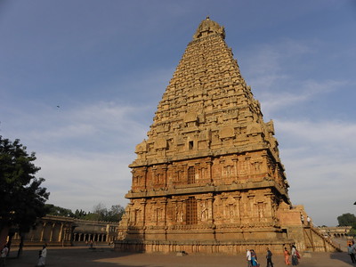
The Great Living Chola Temples represent the development of the architecture of the Chola Empire and the Tamil civilisation in Southern India.
These three granite temples are dedicated to Shiva and are living temples. The Brihadisvara Temple in Thanjavur is the earliest and most representative monument and has influenced the other two (the temples of Gangaikondacholapuram and Darasuram). Their layout differs from other South Indian temples because of their tall and elaborately sculptured Vimanas (sanctuaries), whereas elsewhere the gates are the highest points.
Community Perspective: Most visited the Big Temple in Thanjavur, whose Vimana is exuberant. There’s no entrance fee or limitations for non-Hindus. Only take your shoes off.
rusal london ,england - 01-May-05
The brihadisvara temple is magnificent.
I was there every evening Puja,for darshan Of the giant Lingam,for three days,and on millenium eve.
To have been at the foot of the biggest lingam in India, in one of the most spectacular stone temples in the world was a very special way to turn a millenium.
I hope to return this lifetime.
if you are near or in tanjore dont miss it!
Read OnGough and Inaccessible Islands
Gough and Inaccessible Islands are known for their undisturbed state and large seabird population.
These two islands in the Tristan da Cunha archipelago are volcanic islands rising from the South Atlantic Ocean, about 350km from each other. Gough Island holds almost the entire world population of the Tristan albatross and the Atlantic Petrel, and it has two endemic land birds including the almost flightless Gough moorhen. Inaccessible Island is characterized by steep cliffs around its entire coastline. It supports 10% of the global population of Northern Rockhopper Penguins and is the most important breeding site for Great Shearwaters.
Community Perspective: This is a rare site to visit. Solivagant did so in 2002 on an expedition cruise taking in the mid-Atlantic islands, and reports on the circumnavigation of Gough Island, the luxuriant vegetation and orgasmic twitchers.
Solivagant UK - 01-May-05

Gough Island is the "ultimate" for us "WHS collectors"! But how to visit this "oh so remote island" where no one is even allowed to land - so important is it to keep its ecosystem pristine!
Note that the UK has 3 remote island sites - StKilda, Henderson and Gough - added in 86, 88 and 95 respectively
Read OnGuanacaste

The 'Area de Conservación Guanacaste' covers diverse landscape and forest types, including a rare vast stretch of Pacific Tropical Dry Forest.
This ecosystem ranges from 12 miles into the Pacific Ocean, with its upwelling and coral reefs, to the coastal dry tropical forest and the lowland Caribbean rainforest it interacts with. It is a habitat for threatened or rare fauna species like the False Vampire Bat, Olive Ridley Sea Turtle, Jaguar, and Mangrove Hummingbird.
Community Perspective: located in northern Costa Rica not far from Liberia airport, this is a contiguous area of seven protected zones. Rincon de la Vieja National Park is the most visited of those, while Horizontes Forestry Experiment Station is easily accessible too.
Anthony Sun USA - 17-Dec-08
Guanacaste is now very popular as a gateway to the resorts in northern Costa Rica. It has been explosive since the airport opened in Liberia and hotels like Four Seasons in Papagoya became chic.
There is much to do and I signed up for the zip line experience and horse back trail ride in the Rincon de la Vieja National Park. A highlight of the trail ride is a dip in hot springs in the forest.
The one other highlight is to get near Tamarine Beach to watch the Leatherback turtles come up and lay eggs on the beach. I do not think the beach is part of Guanacaste but no matter. The quantity of turtles are diminishing rapidly. Their shells are 5-6 feet and are amazing to watch in the middle of the night.
Read OnImperial Palace
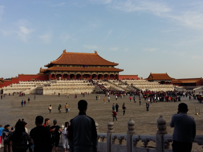
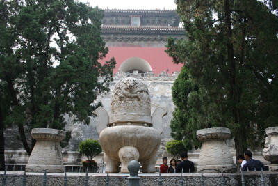
The Imperial Palaces of the Ming and Qing Dynasties in Beijing and Shenyang with their grand palatial architecture represent State power in late feudal China
The Imperial Palace of the Ming Dynasty, commonly known as the Forbidden City, lies in Beijing and has been the residence of the Ming emperors since 1421. It represents the ritual and court culture of that period. The Imperial Palace of the Qing Dynasty was the secondary capital; the palace dates from the 17th century and its plan and architecture show the Manchu culture of this dynasty, including sacrificial places to practice Shamanism.
Community Perspective: The Forbidden City in Beijing stands out for its enormous scale, and takes hours to explore if you stray off the main path. The palace in Shenyang shows the intricate design of Manchu architecture.
C H Ho Hong Kong, China - 01-May-05
The Forbidden City may be the largest palace in East Asia. However, many treasury are stored in the Imperial Palace Museum in Taiwan. The former government moved the treasury to Taiwan before turnover to Communists in 1949. Therefore, tourists visit the architechture of the palace mainly.
Read OnImperial Tombs
The Imperial Tombs of the Ming and Qing Dynasties are examples of funerary architecture built on the principles of feng shui.
These impressive mausolea were built over the course of five centuries, not only as places to rest the dead but also to accommodate royal ceremonies and to impress. The works combine the architectural arts of the Han and Manchu civilizations.
Community Perspective: After two extensions, this site geographically has strayed far from the well-known Ming Tombs near Beijing (which are usually part of a combination tour with the Great Wall, and where you’ll be “given a dull tour of a few reconstructed buildings”). Zos visited remote Ming Xian Ling in Zhongxiang.
Gladys Singapore - 01-May-05
Most of the tourist sites in China, such as the Ming tombs have concession tickets for the elderly over 65 or 70. Some places requires you to be 65, while some requires you to be 70 in order to qualify for 50% off the adult admission rate. If I remember correctly, the Ming Tombs offer 50% off for seniors above 65. Do remember to bring along your I.D. to prove your age.
Overall, I think it was a nice place to visit, but it will get extremely crowded in the underground palace. There were many local chinese visitors and most of them were quite rude and pushy. Do beware of your personal belongings as the locals have a very bad habit of pushing their way through instead of saying "excuse me".
Read OnSt. Kilda
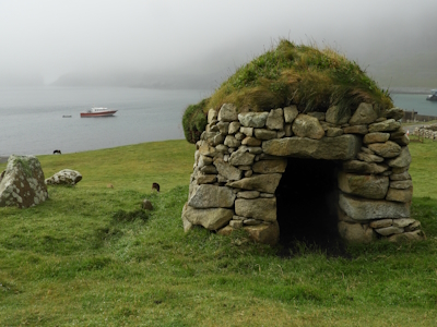
St. Kilda is a remote and uninhabited archipelago in Scotland's Outer Hebrides, renowned as a seabird breeding station and for its past human occupation in extreme conditions.
The volcanic origins produced a dramatic landscape of exceptional cliffs and underwater scenery. The islands were occupied by humans for some 2,000 years, relying on bird products and the keeping of sheep. The remains of 4 settlements are left, the structures dating mostly to the 19th century. The last remaining people asked to be evacuated in 1930 due to a lack of resources to survive. Over 1 million sea birds use the islands, especially gannets, puffins and fulmars.
Community Perspective: It takes good planning beforehand and suitable weather on the day of departure, as it takes at least 2.5 hours across the sea to reach. The best point of departure is Harris, but you can also take it in as part of a longer Expedition Cruise like Solivagant did. Avoid departing from Skye, for reasons described by Nan.
colin palmer london - 01-May-05
Planning for my journey started the previous year following a visit to the Isles of Lewis and Harris for the first time. I stayed at Cairisiadar with Jessie Buchanan in an excellent bed & breakfast overlooking Loch Roag on the west coast of Lewis. Here I met a lady who was I believe in her 70’s who had travelled from Aberdeen and on her way to St.Kilda. Until then I hadn't even heard of this place! She kindly left me a leaflet " Cruising with the MV Cuma".
The weather had not been too kind of late but the day that she was leaving for St.Kilda cleared with sunshine late in the day but with a near gale force wind blowing. I remember seeing the MV Cuma leave and cruise across West Loch Roag heading for the open sea – I took one photograph
Read On